IMAGES TAKEN NEAR TO
Holne, NEWTON ABBOT, TQ13 7SS
Introduction
This page details the photographs taken nearby to TQ13 7SS by members of the Geograph project.
The Geograph project started in 2005 with the aim of publishing, organising and preserving representative images for every square kilometre of Great Britain, Ireland and the Isle of Man.

There are currently over 7.5m images from over14,400 individuals and you can help contribute to the project by visiting https://www.geograph.org.uk
Image Map
Images are licensed for reuse under creativecommons.org/licenses/by-sa/2.0
Notes
- Clicking on the map will re-center to the selected point.
- The higher the marker number, the further away the image location is from the centre of the postcode.
Image Listing (19 Images Found)
Images are licensed for reuse under creativecommons.org/licenses/by-sa/2.0
Image
Details
Distance
1
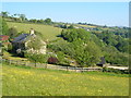
Middle Stoke Farm
Holne Footpath 2 approaches the farm. In the distance is West Stoke Farm.
Image: © Derek Harper
Taken: 9 Jun 2006
0.01 miles
2
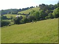
Approaching Middle Stoke Farm
Holne Footpath 2 crosses this field of sheep on a slope above a small side valley of the Dart.
Image: © Derek Harper
Taken: 9 Jun 2006
0.02 miles
3
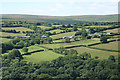
Holne: Middle Stoke
Seen from across the valley, from the Two Moors Way, also know as Dr Blackall’s Drive
Image: © Martin Bodman
Taken: 21 Jul 2008
0.02 miles
4
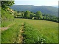
Fields near Middle Stoke Farm
Seen from Holne Footpath 2, these grass fields are high above the Dart valley, which can be seen ahead. On the far side of the valley is steep moorland, followed near its crest by the Two Moors Way.
Image: © Derek Harper
Taken: 9 Jun 2006
0.10 miles
5
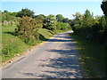
Lane to West Stoke Farm
Further north along Image The turning into Middle Stoke, shown in Image, is at the right bend. The wide verge on the left doubtless relates to this being used as a drove.
Image: © Derek Harper
Taken: 9 Jun 2006
0.11 miles
6
Entrance to Middle Stoke Farm
Image: © Derek Harper
Taken: 9 Jun 2006
0.12 miles
7
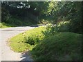
Lane from West Stoke Farm
Looking in the opposite direction from close to where Image was taken.
Image: © Derek Harper
Taken: 9 Jun 2006
0.13 miles
8
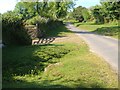
Lane to West Stoke Farm
A reverse view of Image, with the shadow of the gate hidden. The verge is in the process of shifting sides here.
Image: © Derek Harper
Taken: 9 Jun 2006
0.14 miles
9
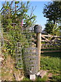
Fencing roll near Middle Stoke Farm
All ready for use beside Holne Footpath 2 from Fore Stoke Farm as it crosses pasture fields high above the Dart.
Image: © Derek Harper
Taken: 9 Jun 2006
0.15 miles
10
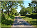
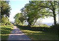
Lane to West Stoke farm
An old drove that leads to just three farms, off the road from Holne up onto the moor.
Image: © Derek Harper
Taken: 9 Jun 2006
0.18 miles