IMAGES TAKEN NEAR TO
Holne, NEWTON ABBOT, TQ13 7RY
Introduction
This page details the photographs taken nearby to TQ13 7RY by members of the Geograph project.
The Geograph project started in 2005 with the aim of publishing, organising and preserving representative images for every square kilometre of Great Britain, Ireland and the Isle of Man.

There are currently over 7.5m images from over14,400 individuals and you can help contribute to the project by visiting https://www.geograph.org.uk
Image Map
Images are licensed for reuse under creativecommons.org/licenses/by-sa/2.0
Notes
- Clicking on the map will re-center to the selected point.
- The higher the marker number, the further away the image location is from the centre of the postcode.
Image Listing (9 Images Found)
Images are licensed for reuse under creativecommons.org/licenses/by-sa/2.0
Image
Details
Distance


3
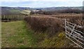
Field boundary near Staddicombe
An old gate reinforces the field boundary by the road just north of Humphrey's Cross.
Image: © Derek Harper
Taken: 5 Mar 2006
0.22 miles
4
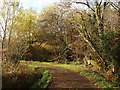
Lane near Shuttaford
Magpie Hill, having completed its steep descent from Humphrey's Cross, makes the extravagant bend referred to in Image
Image: © Derek Harper
Taken: 16 Nov 2008
0.22 miles
5
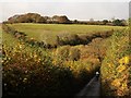
Valley above Shuttaford
Magpie Hill descends to the valley where it makes a sharp bend towards Shuttaford.
Image: © Derek Harper
Taken: 16 Nov 2008
0.22 miles
6
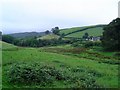
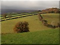
Stoodley - Dartmoor
Valley near Stoodley. This scene is typical of isolated farmland on the edges of the moor.
Image: © Richard Knights
Taken: Unknown
0.23 miles
7
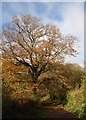
Tree at foot of Magpie Hill
This tree, still hanging on to some of its autumn leaves, can be seen in Image
Image: © Derek Harper
Taken: 16 Nov 2008
0.23 miles
8
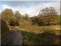
Lane near Shuttaford
The lane from Holne approaches the bend seen in Image, where it swings across the little valley and starts climbing Magpie Hill. The oak on the right is featured in Image
Image: © Derek Harper
Taken: 16 Nov 2008
0.24 miles
9
Countryside at Shuttaford
Like Image, taken from Humphrey's Cross, but looking to the right, and including various elements appearing in Image The nearest tree is on Magpie Hill, the lane dropping towards Shuttaford from the junction.
Image: © Derek Harper
Taken: 16 Nov 2008
0.25 miles