IMAGES TAKEN NEAR TO
Hele Cross, NEWTON ABBOT, TQ13 7QX
Introduction
This page details the photographs taken nearby to Hele Cross, TQ13 7QX by members of the Geograph project.
The Geograph project started in 2005 with the aim of publishing, organising and preserving representative images for every square kilometre of Great Britain, Ireland and the Isle of Man.

There are currently over 7.5m images from over14,400 individuals and you can help contribute to the project by visiting https://www.geograph.org.uk
Image Map
Images are licensed for reuse under creativecommons.org/licenses/by-sa/2.0
Notes
- Clicking on the map will re-center to the selected point.
- The higher the marker number, the further away the image location is from the centre of the postcode.
Image Listing (20 Images Found)
Images are licensed for reuse under creativecommons.org/licenses/by-sa/2.0
Image
Details
Distance
1
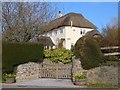
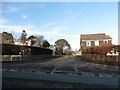
Thatched house, Hele Cross
Named thatchetts on the nameplate, but mapped as Little Barn Cottage.
Image: © Derek Harper
Taken: 12 Apr 2006
0.00 miles
2
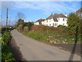
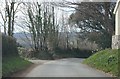
Near Hele Cross, Ashburton
Some ribbon development on the lane between Hele Cross and Holne Turn, seen looking roughly west.
Image: © Derek Harper
Taken: 12 Apr 2006
0.01 miles
3
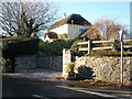
Thatchetts, Hele Cross, near Ashburton
Image: © Roger Cornfoot
Taken: 3 Dec 2008
0.01 miles
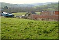
7
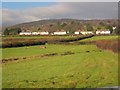
Houses at Hele
A detail of the scene in Image, again with the source of the small stream and the field boundaries. In the background is the wooded high ground around Ausewell Rocks.
Image: © Derek Harper
Taken: 9 Dec 2013
0.07 miles
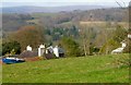
8
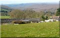
Barn, Adams Hele
Looking left from where Image] was taken, with a view to the wooded Dart valley.
Image: © Derek Harper
Taken: 12 Apr 2006
0.11 miles
9
Barns, Adams Hele
Some of the farm buildings shown in Image], plus the boat.
Image: © Derek Harper
Taken: 12 Apr 2006
0.11 miles
10
Adams Hele
A detail of the scene in Image], with the listed farmhouse https://www.historicengland.org.uk/listing/the-list/list-entry/1206377 , and a view to the Dart valley. In the centre are conifers at the River Dart Country Park.
Image: © Derek Harper
Taken: 12 Apr 2006
0.12 miles