IMAGES TAKEN NEAR TO
Poundsgate, NEWTON ABBOT, TQ13 7PS
Introduction
This page details the photographs taken nearby to TQ13 7PS by members of the Geograph project.
The Geograph project started in 2005 with the aim of publishing, organising and preserving representative images for every square kilometre of Great Britain, Ireland and the Isle of Man.

There are currently over 7.5m images from over14,400 individuals and you can help contribute to the project by visiting https://www.geograph.org.uk
Image Map
Images are licensed for reuse under creativecommons.org/licenses/by-sa/2.0
Notes
- Clicking on the map will re-center to the selected point.
- The higher the marker number, the further away the image location is from the centre of the postcode.
Image Listing (13 Images Found)
Images are licensed for reuse under creativecommons.org/licenses/by-sa/2.0
Image
Details
Distance
1
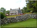
Rogues Roost
A house overlooking the East Dart valley on the slopes of Corndon Down.
Image: © Derek Harper
Taken: 13 Jun 2006
0.06 miles
2
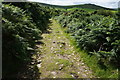
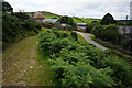
Bridleway from Cator Gate
Heading towards Sherwell, which is just ahead unseen in the valley.
Image: © jeff collins
Taken: 29 Jul 2015
0.09 miles
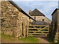
4
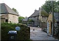
Sherwell or Sherril
Mapped as both, listed as the former. The thatched farmhouse is described at http://www.britishlistedbuildings.co.uk/en-441399-sherwell-farmhouse-widecombe-in-the-moor . Both it and the barn on the left, shown in Image, are former longhouses.
Image: © Derek Harper
Taken: 13 Jun 2006
0.13 miles
5
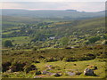
Sherril and Rogue's Roost from Corndon Down
Looking down towards the Walla Brook valley. On the horizon, the forest above Fernworthy reservoir.
Image: © Derek Harper
Taken: 13 Jun 2006
0.14 miles
6
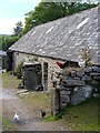
Chickens at Sherril
A rooster and some of the flock at the entrance to the farm at Sherwell. Behind them is what was possibly a medieval longhouse http://www.britishlistedbuildings.co.uk/en-441400-outbuilding-about-20-metres-north-east-o . It's here behind the camera that the Two Moors Way leaves the lane to Babeny.
Image: © Derek Harper
Taken: 13 Jun 2006
0.14 miles
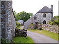
7
Farm at Sherwell
The farmhouse has a lovely thatched roof.
Image: © jeff collins
Taken: 29 Jul 2015
0.14 miles
8
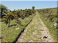
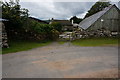
Approaching Sherwell
On the Bridleway from Cator Gate. The road on the right heads round to Babeny and the riding stables.
Image: © jeff collins
Taken: 29 Jul 2015
0.15 miles
9
Hornets Castle
A view of the unusual C19 listed building http://www.britishlistedbuildings.co.uk/en-441072-hornets-castle-widecombe-in-the-moor shown from the other direction in Image and Image Seen from the Two Moors Way on Widecombe in the Moor Footpath 26.
Image: © Derek Harper
Taken: 13 Jun 2006
0.16 miles
10
Hornets Castle
A closer view of the listed building seen in Image http://www.britishlistedbuildings.co.uk/en-441072-hornets-castle-widecombe-in-the-moor . The lean-to addition gives it a distinctive shape.
Image: © Derek Harper
Taken: 13 Jun 2006
0.17 miles