IMAGES TAKEN NEAR TO
Widecombe-in-the-Moor, NEWTON ABBOT, TQ13 7PN
Introduction
This page details the photographs taken nearby to TQ13 7PN by members of the Geograph project.
The Geograph project started in 2005 with the aim of publishing, organising and preserving representative images for every square kilometre of Great Britain, Ireland and the Isle of Man.

There are currently over 7.5m images from over14,400 individuals and you can help contribute to the project by visiting https://www.geograph.org.uk
Image Map
Images are licensed for reuse under creativecommons.org/licenses/by-sa/2.0
Notes
- Clicking on the map will re-center to the selected point.
- The higher the marker number, the further away the image location is from the centre of the postcode.
Image Listing (27 Images Found)
Images are licensed for reuse under creativecommons.org/licenses/by-sa/2.0
Image
Details
Distance
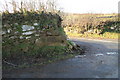
1
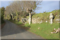
Road at Drywell
Drywell Cross is at the right of the image.
Image: © MrC
Taken: 27 Oct 2009
0.10 miles
2
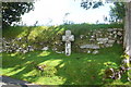
Drywell Cross
This cross has been restored and resited, although its original site is unknown. It is now beside the road, NE of a cross-roads near Drywell. More can be read about this cross at http://www.legendarydartmoor.co.uk/ward_bussell.htm
Image: © Nigel Mole
Taken: 24 Jul 2007
0.10 miles
3
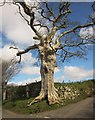
Oak at Drywell Cross
I took this more for the fine oak at the crossroads than the wayside cross tucked away beneath it. See also http://www.geograph.org.uk/search.php?i=49212445 and http://list.english-heritage.org.uk/resultsingle.aspx?uid=1241515&searchtype=mapsearch .
Image: © Derek Harper
Taken: 9 Apr 2014
0.11 miles
4
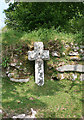
Drywell Wayside Cross by Cross Gate crossroads
Drywell Cross or Cross Gate Cross, old head and shaft, Starkey No.83 by the UC road, in parish of Widecombe in the Moor (Teignbridge District), Cross Gate crossroads, North of Jordan Manor and 250m South West of Dockwell Farm, against a hedge bank below a large old maple tree.
Grade II listed.
List Entry Number: 1241515 https://historicengland.org.uk/listing/the-list/list-entry/1241515
Surveyed
Milestone Society National ID: DVTE_WID01
Image: © Alan Rosevear
Taken: 25 May 2010
0.11 miles
5
Stone gatehanger
This socketed stone, built into a wall at Drywell cross, was once used as a pivot for a gate.
Image: © Guy Wareham
Taken: 8 Jan 2011
0.11 miles
6
Widecombe in the Moor: entrance to Drywell
By the lane to Jordan
Image: © Martin Bodman
Taken: 24 May 2009
0.12 miles
7

Widecombe in the Moor: Drywell Cross
Erected here by the Dartmoor Preservation Association in 1967. It had been discovered in a wall in the 1930s
Image: © Martin Bodman
Taken: 24 May 2009
0.13 miles
8
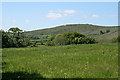
Widecombe in the Moor: towards Corndon Tor
Seen from a lane near Dockwell
Image: © Martin Bodman
Taken: 24 May 2009
0.14 miles
9
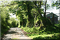
Widecombe in the Moor: lane near Dockwell
Image: © Martin Bodman
Taken: 24 May 2009
0.14 miles
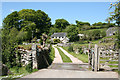
10
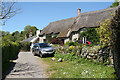
Widecombe in the Moor: cottages at Jordan
Thatch and granite
Image: © Martin Bodman
Taken: 24 May 2009
0.16 miles