IMAGES TAKEN NEAR TO
Tuckers Meadow, NEWTON ABBOT, TQ13 7FR
Introduction
This page details the photographs taken nearby to Tuckers Meadow, TQ13 7FR by members of the Geograph project.
The Geograph project started in 2005 with the aim of publishing, organising and preserving representative images for every square kilometre of Great Britain, Ireland and the Isle of Man.

There are currently over 7.5m images from over14,400 individuals and you can help contribute to the project by visiting https://www.geograph.org.uk
Image Map
Images are licensed for reuse under creativecommons.org/licenses/by-sa/2.0
Notes
- Clicking on the map will re-center to the selected point.
- The higher the marker number, the further away the image location is from the centre of the postcode.
Image Listing (194 Images Found)
Images are licensed for reuse under creativecommons.org/licenses/by-sa/2.0
Image
Details
Distance
1
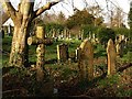
Graveyard, Ashburton (2)
Graves near the southern edge of Image, seen from the Church Path, which is followed by Ashburton Footpath 8.
Image: © Derek Harper
Taken: 12 Dec 2008
0.03 miles
2
Graveyard, Ashburton (3)
Image: © Derek Harper
Taken: 12 Dec 2008
0.04 miles
3
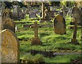
Graveyard, Ashburton
A view across graves from the Church Path. This is a large irregularly shaped graveyard extending some way south of St Andrew’s Church.
Image: © Derek Harper
Taken: 12 Dec 2008
0.06 miles
4
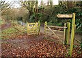
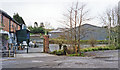
Signs by Chuley Road, Ashburton
The footpath sign indicates Ashburton Footpath 8, which follows the Church Path into the town centre. The sign on the gate has the lower half of the "stop, look, listen" warning sign for the railway, which has now become Ashburton Footpath 24 (on the left, and christened "Bulliver's Way" after the traditional name for the railway). Chuley Road has recently emerged from Image; the dual carriageway which has replaced the trains is just a few metres above to the right.
Image: © Derek Harper
Taken: 12 Dec 2008
0.09 miles
5
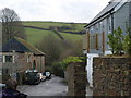
Church Path, Ashburton
Here the path shown in Image is a stretch of road connected to the Old Totnes Road via Stonepark, to the right beyond the new house. Past the old auction rooms on the left, the path drops to cross River Ashburn and the former railway in quick succession to the scene shown in Image
On the far hill a field boundary climbs to meet Cabbage Hill, the lane to Landscove.
Image: © Derek Harper
Taken: 13 Dec 2008
0.10 miles
6
Site of Ashburton station, 1995
View northwards, which would have been towards the buffer-stops of the terminus in Ashburton town centre of the ex-GWR branch line from Totnes, closed to passengers 3/11/58, to goods 10/9/62. (Buckfastleigh - Totnes was acquired by the South Devon (heritage) Railway and reopened on 6/4/69).
Image: © Ben Brooksbank
Taken: 20 Apr 1995
0.11 miles
7

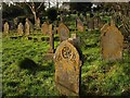
Graveyard of St Andrew's church, Ashburton
I was struck by the simplicity of this simple grave marked by just a wooden cross. It bore the name of what I presumed was a young girl. Her loved ones had covered her plot with beautiful white begonias in wonderful full bloom at the time of my visit. It made me feel quite sad.
Image: © Derek Voller
Taken: 16 Jun 2014
0.12 miles
8
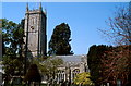
Ashburton, St Andrew's church
This church was entirely rebuilt in the 15th century, with its 92 ft tower.
Image: © Patrick GUEULLE
Taken: Unknown
0.12 miles
9
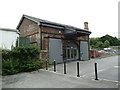
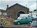
Former railway building Ashburton
This is probably a former goods shed on the former station site.
Image: © Chris Allen
Taken: 13 Aug 2011
0.12 miles
10
Former goods shed, Ashburton
Next to the former wooden station building that is now a garage. The goods shed is office accommodation.
Image: © Chris Allen
Taken: 13 Aug 2011
0.12 miles