IMAGES TAKEN NEAR TO
Miners Close, NEWTON ABBOT, TQ13 7FE
Introduction
This page details the photographs taken nearby to Miners Close, TQ13 7FE by members of the Geograph project.
The Geograph project started in 2005 with the aim of publishing, organising and preserving representative images for every square kilometre of Great Britain, Ireland and the Isle of Man.

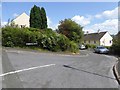
There are currently over 7.5m images from over14,400 individuals and you can help contribute to the project by visiting https://www.geograph.org.uk
Image Map
Images are licensed for reuse under creativecommons.org/licenses/by-sa/2.0
Notes
- Clicking on the map will re-center to the selected point.
- The higher the marker number, the further away the image location is from the centre of the postcode.
Image Listing (46 Images Found)
Images are licensed for reuse under creativecommons.org/licenses/by-sa/2.0
Image
Details
Distance
1
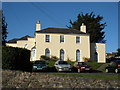
Apartment building, Eastern Road, Ashburton
Image: © Roger Cornfoot
Taken: 3 Dec 2008
0.05 miles
2
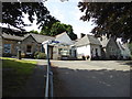
Ashburton & Buckfastleigh Hospital
Seen looking up the driveway.
Image: © Chris Allen
Taken: 17 Jul 2017
0.06 miles
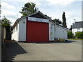
4
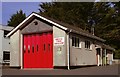
Ashburton Fire Station
Ashburton Fire Station, Eastern Road, Ashburton, Devon.
Image: © Kevin Hale
Taken: 21 Apr 1991
0.07 miles
5
Little Roborough, Ashburton
A cul-de-sac of 20th century housing on the edge of Ashburton
Image: © David Smith
Taken: 6 Aug 2014
0.08 miles
6
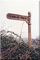
Direction Sign ? Signpost
Located at the junction with the Terrace Walk on Roborough Lane in Ashburton parish. 1 arm and acorn finial. See also http://www.flickr.com/photos/bridgemarkertim/8595286941/.
Milestone Society National ID: DV_SX7570
Image: © W Marsh
Taken: Unknown
0.09 miles
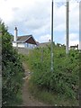
7
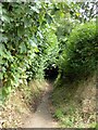
Footpath to Balland Lane, Ashburton
An old footpath between hedges from Roborough Lane down the hill to Balland Lane
Image: © David Smith
Taken: 6 Aug 2014
0.12 miles
8
Roborough Lane, Ashburton
Once it was a lane, now it is lined with houses. On the left, by the lamppost, is the start of a footpath, the Terrace Walk. It connects with a further path on the right
Image: © David Smith
Taken: 6 Aug 2014
0.13 miles
9
Terrace Walk, Ashburton
A footpath Image which runs above Ashburton and drops down to by the river at North Street
Image: © David Smith
Taken: 6 Aug 2014
0.13 miles
10
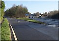
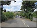
Junction on A38, Ashburton
The slip road leads into the northeastern end of Ashburton; the B3352 is actually the current number of the former main road through the centre of the town. Meanwhile, the expressway sweeps up a long hill to Caton Cross.
Image: © Derek Harper
Taken: 9 Mar 2009
0.14 miles