IMAGES TAKEN NEAR TO
Whistley Hill, NEWTON ABBOT, TQ13 7DW
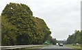
Introduction
This page details the photographs taken nearby to Whistley Hill, TQ13 7DW by members of the Geograph project.
The Geograph project started in 2005 with the aim of publishing, organising and preserving representative images for every square kilometre of Great Britain, Ireland and the Isle of Man.

There are currently over 7.5m images from over14,400 individuals and you can help contribute to the project by visiting https://www.geograph.org.uk
Image Map
Images are licensed for reuse under creativecommons.org/licenses/by-sa/2.0
Notes
- Clicking on the map will re-center to the selected point.
- The higher the marker number, the further away the image location is from the centre of the postcode.
Image Listing (253 Images Found)
Images are licensed for reuse under creativecommons.org/licenses/by-sa/2.0
Image
Details
Distance
1
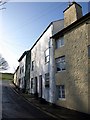
Whistley Hill, Ashburton
A terrace climbs the steep lane out of Ashburton. See Image for the building on the right. The next three are described at http://www.imagesofengland.org.uk/Details/Default.aspx?id=376195&mode=adv .
Image: © Derek Harper
Taken: 9 Mar 2009
0.00 miles
2
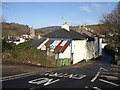
Whistley Hill, Ashburton
Seen from its junction with the A38 expressway, with St Lawrence's Tower to the left. All the cottages on the lane are listed - see http://www.imagesofengland.org.uk/Details/Default.aspx?id=376198&mode=adv for the first building.
Image: © Derek Harper
Taken: 9 Mar 2009
0.01 miles
3

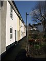
Whistley Hill and Queen's Square, Ashburton
An intriguing corner of the town, with closes opening off one another at the side of an old lane (left) leading uphill eastwards from the town centre, now almost immediately reaching the A38 expressway. The first two houses on this lane, Whistley Hill, are described at http://www.imagesofengland.org.uk/details/default.aspx?id=376194 .
Image: © Derek Harper
Taken: 9 Mar 2009
0.02 miles
4
Station Cottages, Ashburton
This row of eight cottages is only accessible by footpaths. Seen from Ashburton Footpath 11.
Image: © Derek Harper
Taken: 9 Mar 2009
0.02 miles
7
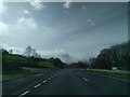
A minor road junction on the A38 near Ashburton
Image: © Rob Purvis
Taken: 2 Mar 2019
0.04 miles
8
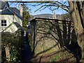
Footpath, Ashburton
This is Ashburton Footpath 11, which probably counts as a ginnel, although it could be a snicket, especially where it is unwalled. Above the outbuilding is St Lawrence's Tower.
Image: © Derek Harper
Taken: 9 Mar 2009
0.04 miles
9
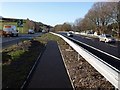
Footpath crossing, A38, Ashburton
I was slightly surprised that there is no bridge or underpass to allow pedestrians and cyclists to cross the very busy A38 at Whistley Hill. This is a new path which cuts between the crash barriers.
Image: © Derek Harper
Taken: 9 Mar 2009
0.04 miles
10

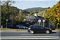
Whistley Hill meets the A38
Vehicles cannot continue down Whistley Hill into the town centre, but must turn left and approach Ashburton from Peartree Cross. Pedestrians have Image Across the dual carriageway, if you can make it, is the scene shown in Image
Image: © Derek Harper
Taken: 9 Mar 2009
0.05 miles