IMAGES TAKEN NEAR TO
Beverley Gardens, NEWTON ABBOT, TQ13 7BN
Introduction
This page details the photographs taken nearby to Beverley Gardens, TQ13 7BN by members of the Geograph project.
The Geograph project started in 2005 with the aim of publishing, organising and preserving representative images for every square kilometre of Great Britain, Ireland and the Isle of Man.

There are currently over 7.5m images from over14,400 individuals and you can help contribute to the project by visiting https://www.geograph.org.uk
Image Map
Images are licensed for reuse under creativecommons.org/licenses/by-sa/2.0
Notes
- Clicking on the map will re-center to the selected point.
- The higher the marker number, the further away the image location is from the centre of the postcode.
Image Listing (29 Images Found)
Images are licensed for reuse under creativecommons.org/licenses/by-sa/2.0
Image
Details
Distance
2
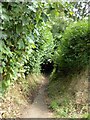
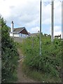
Footpath to Balland Lane, Ashburton
An old footpath between hedges from Roborough Lane down the hill to Balland Lane
Image: © David Smith
Taken: 6 Aug 2014
0.07 miles
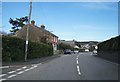
3
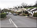
Roborough Lane, Ashburton
Once it was a lane, now it is lined with houses. On the left, by the lamppost, is the start of a footpath, the Terrace Walk. It connects with a further path on the right
Image: © David Smith
Taken: 6 Aug 2014
0.08 miles
5
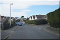
Terrace Walk, Ashburton
A footpath Image which runs above Ashburton and drops down to by the river at North Street
Image: © David Smith
Taken: 6 Aug 2014
0.08 miles
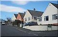
6
Houses on Roborough Lane
Suburban bungalows on the edge of Ashburton.
Image: © Tony Atkin
Taken: 6 Apr 2012
0.09 miles
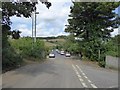
8
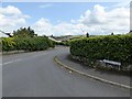
Balland Park, Ashburton
A road into a 20th century housing estate with a view to the hills beyond the A38
Image: © David Smith
Taken: 6 Aug 2014
0.09 miles
9
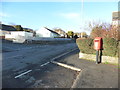
Letter box on Balland Lane, Ashburton
Image: © Ruth Sharville
Taken: 8 Mar 2015
0.13 miles
10
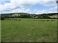
Cattle on the edge of Ashburton, and wooded hills
The land is rising towards the southern edge of Dartmoor; the buildings are farm buildings at Cuddyford Cross
Image: © David Smith
Taken: 6 Aug 2014
0.15 miles