IMAGES TAKEN NEAR TO
River Valley Road, NEWTON ABBOT, TQ13 0HP
Introduction
This page details the photographs taken nearby to River Valley Road, TQ13 0HP by members of the Geograph project.
The Geograph project started in 2005 with the aim of publishing, organising and preserving representative images for every square kilometre of Great Britain, Ireland and the Isle of Man.

There are currently over 7.5m images from over14,400 individuals and you can help contribute to the project by visiting https://www.geograph.org.uk
Image Map
Images are licensed for reuse under creativecommons.org/licenses/by-sa/2.0
Notes
- Clicking on the map will re-center to the selected point.
- The higher the marker number, the further away the image location is from the centre of the postcode.
Image Listing (83 Images Found)
Images are licensed for reuse under creativecommons.org/licenses/by-sa/2.0
Image
Details
Distance
1
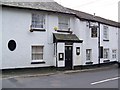
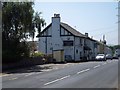
The Anchor Inn, Chudleigh Knighton
The pub is on Plymouth Road.
Image: © Maigheach-gheal
Taken: 17 Aug 2008
0.04 miles
2
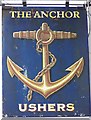
Sign for the Anchor Inn
This common sign was probably first used as a convenient visual symbol, especially by landlords who had connections with the sea or who wished to attract seamen as customers.
Image: © Maigheach-gheal
Taken: 17 Aug 2008
0.05 miles
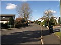
3
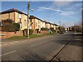
Houses in Chudleigh Knighton
Hennock Footpath 19 arrives up Bellamarsh lane at the B3344 opposite these brick houses.
Image: © Derek Harper
Taken: 17 Feb 2009
0.06 miles
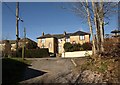
4
River Valley Road, Chudleigh Knighton
Part of a modern estate on the slopes of the Teign valley. On the left is Harvey's Close.
Image: © Derek Harper
Taken: 17 Feb 2009
0.06 miles
5
Houses in Chudleigh Knighton
Another view along the row of brick semis on the B3344 also shown in Image This is at the junction with Teign View (left).
Image: © Derek Harper
Taken: 17 Feb 2009
0.06 miles
6
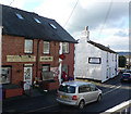
Chudleigh Knighton facilities
Looking along the road that goes to Bovey Tracey, we have on the left the village stores with an off licence and post office and then Melissas hair and beauty salon.
Image: © paul dickson
Taken: 31 Mar 2008
0.09 miles
7
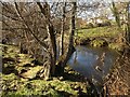
River Teign at Chudleigh Knighton
The river glides past an alder, with a glimpse of housing on Harvey's Close in Chudleigh Knighton on the other side.
Image: © Derek Harper
Taken: 17 Feb 2009
0.10 miles
8
Bus shelter and the Anchor Inn, Chudleigh Knighton
Image: © David Smith
Taken: 12 Jul 2013
0.10 miles
9
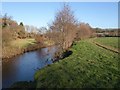
River Teign at Chudleigh Knighton
Like Image, a view upstream from the partly undercut riverbank near Kingsteignton Footpath 6 (the line of the path officially runs along the foot of the A38 embankment, but I can't imagine anyone would walk there in preference to the delightful riverside). Alders are showing a chocolate-brown as their catkins come out.
Image: © Derek Harper
Taken: 12 Dec 2010
0.11 miles
10
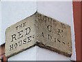
Date stone, Post Office, Chudleigh Knighton
The date stone is on the corner of the post office.
Image: © Maigheach-gheal
Taken: 17 Aug 2008
0.11 miles