IMAGES TAKEN NEAR TO
Chudleigh, NEWTON ABBOT, TQ13 0DZ
Introduction
This page details the photographs taken nearby to TQ13 0DZ by members of the Geograph project.
The Geograph project started in 2005 with the aim of publishing, organising and preserving representative images for every square kilometre of Great Britain, Ireland and the Isle of Man.

There are currently over 7.5m images from over14,400 individuals and you can help contribute to the project by visiting https://www.geograph.org.uk
Image Map
Images are licensed for reuse under creativecommons.org/licenses/by-sa/2.0
Notes
- Clicking on the map will re-center to the selected point.
- The higher the marker number, the further away the image location is from the centre of the postcode.
Image Listing (28 Images Found)
Images are licensed for reuse under creativecommons.org/licenses/by-sa/2.0
Image
Details
Distance
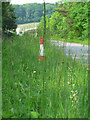
1
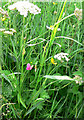
Grass Vetchling
This beautiful red flower is situated near the chudleigh slip road.
Image: © paul dickson
Taken: 1 Jun 2008
0.06 miles
2
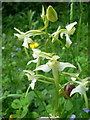
The snail and the Butterfly Orchid
Near the Chudleigh slip road.
Image: © paul dickson
Taken: 1 Jun 2008
0.06 miles
4
Goat's Beard
Near the Chudleigh slip road.
Image: © paul dickson
Taken: 1 Jun 2008
0.06 miles
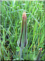
5
Greater Butterfly Orchid
Found on the A38 sliproad going towards Chudleigh. The petrol station can be seen in the distance.
Image: © paul dickson
Taken: 1 Jun 2008
0.09 miles
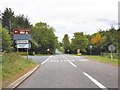
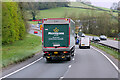
6

A38, South of Harcombe Cross
Heading north.
Image: © Pierre Terre
Taken: 20 Jun 2009
0.13 miles
8
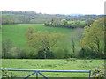
Kate Brook valley from Sticksend
Looking west across the valley from Sticksend Lane, a very narrow winding lane.
Image: © Derek Harper
Taken: 8 May 2006
0.14 miles
9
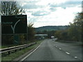
Approaching the Chudleigh junction on the A38 west-bound
Image: © Rob Purvis
Taken: 8 Nov 2009
0.15 miles
10
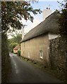
Crammers farmhouse
"Probably C18 ... a vernacular house in a conspicuous position adjacent to the road" http://list.historicengland.org.uk/resultsingle.aspx?uid=1334234&searchtype=mapsearch . The barn is one of several other farm buildings on the right, close to the Kate Brook.
Image: © Derek Harper
Taken: 2 Oct 2014
0.16 miles