IMAGES TAKEN NEAR TO
Chudleigh, NEWTON ABBOT, TQ13 0DH
Introduction
This page details the photographs taken nearby to TQ13 0DH by members of the Geograph project.
The Geograph project started in 2005 with the aim of publishing, organising and preserving representative images for every square kilometre of Great Britain, Ireland and the Isle of Man.

There are currently over 7.5m images from over14,400 individuals and you can help contribute to the project by visiting https://www.geograph.org.uk
Image Map
Images are licensed for reuse under creativecommons.org/licenses/by-sa/2.0
Notes
- Clicking on the map will re-center to the selected point.
- The higher the marker number, the further away the image location is from the centre of the postcode.
Image Listing (15 Images Found)
Images are licensed for reuse under creativecommons.org/licenses/by-sa/2.0
Image
Details
Distance
1
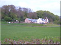
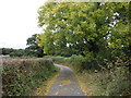
Lower Upcott
The farm lies next to a disused quarry.
Image: © Derek Harper
Taken: 8 May 2006
0.05 miles
2
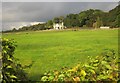
Lower Upcott
Another view of Image from the lane near Lower Amberley.
Image: © Derek Harper
Taken: 2 Oct 2014
0.05 miles

4
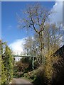
Bridge, Stancott
This bridge seems to be new, as it is hard to detect on any map or satellite image. It crosses the lane climbing past Kerswell House between the two hairpins.
Image: © Derek Harper
Taken: 30 Mar 2008
0.10 miles
5
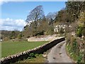
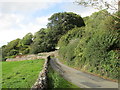
Lane past Kerswell House
Attractive limestone walls line this curious lane, which has just performed two hairpins as it drops past Lower Upcott into the Kate Brook valley. Kerswell House, partly obscured by trees on the right, occupies grounds on a hill that have old-looking features such as the walls, but the house appears modern.
Image: © Derek Harper
Taken: 30 Mar 2008
0.14 miles
6
The road near Kerswell House
Kerswell House is hidden by the trees.
Image: © Jonathan Thacker
Taken: 14 Sep 2015
0.14 miles
7
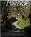
Lane at Amberley
The lane from Amberley Farm towards Kerswell Cross follows a sinuous course as it drops to the Kate Brook valley.
Image: © Derek Harper
Taken: 30 Mar 2008
0.16 miles
8
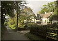
Amberley
Some map scales have "Amberly" but I think this is the correct spelling. Old maps show a cottage called Porcombe here. On the left is the winding lane shown in Image
Image: © Derek Harper
Taken: 2 Oct 2014
0.16 miles
10
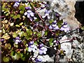
Ivy-leaved toadflax near Kerswell Cross
Cymbalaria muralis on the limestone wall on the northeast side of the lane shown in Image, as it approaches Kerswell Cross.
Image: © Derek Harper
Taken: 30 Mar 2008
0.21 miles