1
Clay Pits Way ? The Haven
At its northern end Clay Pits Way narrows dramatically as it approaches Rixy Park Corner. The cycle path disappears.
Image: © Robin Stott
Taken: 26 Apr 2022
0.01 miles
2
Rixey Park site entrance
The site was a claypit but is now a growing mound of clay waste from Southacre Quarry to the south
Image and, judging by this view, other quarries. Shaping, soil-spreading and planting are happening in places. Seen from the Chudleigh Road, B3193, north of the central group of claypits.
Image: © Robin Stott
Taken: 21 Feb 2010
0.04 miles
3
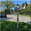
Clay Pits Way ? the narrow north end
Approaching Rixy Park Corner.
Image: © Robin Stott
Taken: 26 Apr 2022
0.04 miles
4
Clay Pits Way ? entry to the quarry waste area
The summit is rough from recent tipping, not yet smoothed off like the lower slopes.
Image: © Robin Stott
Taken: 26 Apr 2022
0.05 miles
5
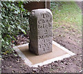
Milestone near Rixey Park Corner (2/2)
Beside the Chudleigh Road B3193 north of the central group of claypits.
Image: © Robin Stott
Taken: 21 Feb 2010
0.05 miles
6
Milestone near Rixey Park Corner (1/2)
Beside the Chudleigh Road B3193, north of the central group of claypits.
Image: © Robin Stott
Taken: 21 Feb 2010
0.05 miles
7
Signs of the Times
In amongst the modern aluminium signs, can be seen a milepost from a bygone age. This is just south of Rixy park, heading towards Kingsteignton.
Image: © Mike Crowe
Taken: 23 May 2005
0.05 miles
8
Old Milestone by the B3193, Rixey Park Corner,
Carved stone post by the B3193, in parish of KINGSTEIGNTON (TEIGNBRIDGE District), Rixey Park Corner, 20m South of Clay Lane junction, on grass verge, warning board (will be moved when road realigned), on West side of road. Newton faces (Arabic), erected by the Totnes & Bridgetown-Pomeroy turnpike trust in the 19th century.
Stone seems to have been reset very close to its original location.
Inscription reads:-
: To / Chud / leigh / 2 / Miles / To / EXON / 12 : : To / Newton / 4 / Miles / To / Totnes / 12 :
Grade II listed.
List Entry Number: 1097085 https://historicengland.org.uk/listing/the-list/list-entry/1097085
Milestone Society National ID: DV_TNCH12.
Image: © T Jenkinson
Taken: 9 Sep 2003
0.05 miles
9
B3193 approaching Rixeypark Corner
For those travelling north on the B3193, these woods mark the end of the ball clay landscape, although there are pits behind the woodland on the left.
Image: © David Smith
Taken: 21 Apr 2011
0.07 miles
10
Clay Pits Way ? Rixy Park Corner fingerpost
The clay wagons come from Heathfield, it is believed; they turn right here.
Image: © Robin Stott
Taken: 26 Apr 2022
0.08 miles


