IMAGES TAKEN NEAR TO
Daddyhole Road, TORQUAY, TQ1 2ED
Introduction
This page details the photographs taken nearby to Daddyhole Road, TQ1 2ED by members of the Geograph project.
The Geograph project started in 2005 with the aim of publishing, organising and preserving representative images for every square kilometre of Great Britain, Ireland and the Isle of Man.

There are currently over 7.5m images from over14,400 individuals and you can help contribute to the project by visiting https://www.geograph.org.uk
Image Map
Images are licensed for reuse under creativecommons.org/licenses/by-sa/2.0
Notes
- Clicking on the map will re-center to the selected point.
- The higher the marker number, the further away the image location is from the centre of the postcode.
Image Listing (286 Images Found)
Images are licensed for reuse under creativecommons.org/licenses/by-sa/2.0
Image
Details
Distance
1
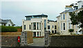
Rutland Heights, Torquay
The Rutland Hotel http://www.geograph.org.uk/search.php?i=150029996 has been converted into nine or ten properties, the detached house on the left being a new build. Elizabeth II postbox TQ1 330 (Image) survives on the perimeter wall.
Image: © Derek Harper
Taken: 1 Jan 2022
0.03 miles
2
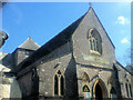
The Little Theatre (formerly St Mark's Church)
Image: © Paul Barnett
Taken: 1 Jan 2015
0.03 miles
4
Rutland Hotel, Torquay
Also shown in Image] and http://www.geograph.org.uk/search.php?i=88784710 . " 'The hotel isn’t viable in its current state' ... The 27-room hotel has been vacant since March last year. The conversion of the hotel will involve the removal of an ‘unsightly, large extension’ at the front" https://www.devonlive.com/news/devon-news/vacant-torquay-hotel-converted-flats-922840 .
On the right is Elizabeth II postbox TQ1 330, better shown in Image
Image: © Derek Harper
Taken: 31 Jul 2018
0.03 miles
5
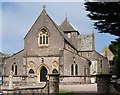
The Little Theatre, Torquay
Formerly St Mark's Church, this 1856 grade II* listed buildinghttps://historicengland.org.uk/listing/the-list/list-entry/1218459 was declared redundant in 1979 and converted (insensitively, say Cherry and Pevsner) to a theatre in 1986. Designed by Anthony Salvin. The tower collapsed in December 1856 during construction and was never rebuilt. "Mostly Early English in style with some Geometric Decorated details."
Image: © Derek Harper
Taken: 25 May 2008
0.03 miles
6
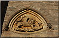
Lion of St Mark
On the facade of the grade II* listed former St Mark's church, shown in Image http://www.imagesofengland.org.uk/Details/Default.aspx?id=390785&mode=adv .
Image: © Derek Harper
Taken: 31 Jul 2018
0.03 miles
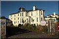
7
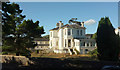
Rutland Hotel, Torquay
Also shown at http://www.geograph.org.uk/search.php?i=88784710 . "Plans to convert the former Rutland Hotel, a Victorian villa in Daddyhole Road, into five flats have been unanimously approved by Torbay Council’s development management committee ... The plans include the partial demolition of existing buildings and construction of one three-bedroom house and two four-bedroom houses" https://www.devonlive.com/news/devon-news/vacant-torquay-hotel-converted-flats-922840 .
Image: © Derek Harper
Taken: 31 Jul 2018
0.04 miles
8
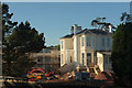
Former Rutland Hotel, Torquay
Work progresses on Image
Image: © Derek Harper
Taken: 25 May 2020
0.04 miles
9
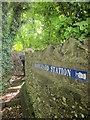
Old path, Daddyhole Road
This intriguing path leads to the rear of the coastguard cottages shown in Image, to the extent that you find yourself in their back yard and must return the same way.
Image: © Derek Harper
Taken: 17 Aug 2014
0.04 miles
10
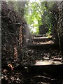
Broomrape by the path, Daddyhole Plain
A few metres up the path shown in Image], with dried specimens of an Orobanche species.
Image: © Derek Harper
Taken: 17 Aug 2014
0.04 miles