IMAGES TAKEN NEAR TO
South Knighton, NEWTON ABBOT, TQ12 6NT
Introduction
This page details the photographs taken nearby to TQ12 6NT by members of the Geograph project.
The Geograph project started in 2005 with the aim of publishing, organising and preserving representative images for every square kilometre of Great Britain, Ireland and the Isle of Man.

There are currently over 7.5m images from over14,400 individuals and you can help contribute to the project by visiting https://www.geograph.org.uk
Image Map
Images are licensed for reuse under creativecommons.org/licenses/by-sa/2.0
Notes
- Clicking on the map will re-center to the selected point.
- The higher the marker number, the further away the image location is from the centre of the postcode.
Image Listing (20 Images Found)
Images are licensed for reuse under creativecommons.org/licenses/by-sa/2.0
Image
Details
Distance
1
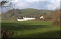
Chipley Cottages
A terrace of rural cottages, seen across the Lemon valley from the A383.
Image: © Derek Harper
Taken: 23 Jan 2009
0.05 miles
2
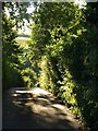
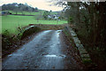
Lane near Chipley
The lane from Millcross Bridge approaches the tiny hamlet of Chipley.
Image: © Derek Harper
Taken: 27 Jul 2008
0.08 miles
3
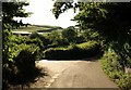
Lane junction, Chipley
The lane shown in Image reaches a junction with the lane on the left heading into the few houses that comprise the hamlet, while the lane on the right climbs to South Knighton. The farm buildings are at Chipley Farm.
Image: © Derek Harper
Taken: 27 Jul 2008
0.11 miles
4
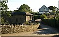
Chipley
About a third of Chipley, seen from the junction shown in Image he converted barns were presumably once part of Chipley Manor, the building on the right.
Image: © Derek Harper
Taken: 27 Jul 2008
0.12 miles
5
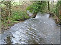
River Lemon at Chipley Bridge
Looking downstream from the bridge; Image] looks upstream.
Image: © Derek Harper
Taken: 26 Mar 2006
0.14 miles
6
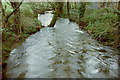
River Lemon at Chipley Bridge
The view downstream is also shown, twelve years previously, at Image
Image: © Derek Harper
Taken: 19 Dec 2018
0.14 miles
7
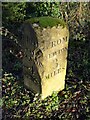
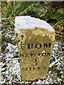
Milestone, Chipley
A listed milestone on the A383 just east of Chipley Mill. "Early or mid C19. Limestone. Low stone of triangular section with flat top. The stone is placed with one point of the triangle facing the road, the 2 adjacent splayed sides carved with inscriptions. On east side is carved : FROM NEWTON 3 MILES. On west side is carved: FROM ASHBURTON 4 MILES." http://www.imagesofengland.org.uk/Details/Default.aspx?id=85212&mode=adv .
Image: © Derek Harper
Taken: 23 Jan 2009
0.15 miles
8

Old Milestone by the A383, Ashburton Road, Bickington parish
Carved stone post by the A383, in parish of BICKINGTON (TEIGNBRIDGE District), 80m East of Chipley Mill at Bone Mill, on grass verge, on North side of road. Ashburton triangle stone, erected by the Newton Bushell turnpike trust in the 18th century.
Inscription reads:-
: FROM / ASH / BURTON / 4 / MILES : : FROM / NEWTON / 3 / MILES :
Grade II listed.
List Entry Number: 1097148 https://historicengland.org.uk/listing/the-list/list-entry/1097148
Milestone Society National ID: DV_NAAB03.
Image: © T Jenkinson
Taken: 4 Sep 2003
0.15 miles
9
Chipley Bridge
Over the River Lemon, and carrying the lane from Chipley Mill to the hamlet of Chipley in the background. A very gloomy winter afternoon. Trees surround the disused Chipley Quarries http://www.geograph.org.uk/gridref/SX8072?centi=SX808721 on the left.
Image: © Derek Harper
Taken: 19 Dec 2018
0.16 miles
10
Old Milestone, Ashburton Rd, A 383
Carved stone post by the A383, in parish of BICKINGTON (TEIGNBRIDGE District), 80m E of Chipley Mill at Bone Mill, on grass verge, on North side of road. Ashburton triangle stone Erected by the Newton Bushell turnpike trust in the 18th century. Alternative view see Image
Inscription reads:- FROM / ASH / BURTON / 4 / MILES / : : FROM / NEWTON / 3 / MILES
Listed.
Milestone Society National ID: DV_NAAB03
Image: © Chris Tawn
Taken: 25 Jan 2021
0.16 miles