IMAGES TAKEN NEAR TO
Liverton, NEWTON ABBOT, TQ12 6HX
Introduction
This page details the photographs taken nearby to TQ12 6HX by members of the Geograph project.
The Geograph project started in 2005 with the aim of publishing, organising and preserving representative images for every square kilometre of Great Britain, Ireland and the Isle of Man.

There are currently over 7.5m images from over14,400 individuals and you can help contribute to the project by visiting https://www.geograph.org.uk
Image Map
Images are licensed for reuse under creativecommons.org/licenses/by-sa/2.0
Notes
- Clicking on the map will re-center to the selected point.
- The higher the marker number, the further away the image location is from the centre of the postcode.
Image Listing (14 Images Found)
Images are licensed for reuse under creativecommons.org/licenses/by-sa/2.0
Image
Details
Distance
1
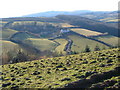
Lenda from Tipleyhill Lane
Looking west from near Tipleyhill Cross over the Liverton Brook valley, with Lenda Farm and wood. 15:58
Image: © Derek Harper
Taken: 4 Mar 2006
0.07 miles
2

Lenda from Tipleyhill Lane
Compare with Image, taken in different season and weather from a little further south along the green lane. Is it a trick of the light, or has the farmhouse been painted in the intervening years.
Image: © Derek Harper
Taken: 19 Oct 2008
0.07 miles
3
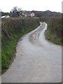
Lenda access road
The farm is set back from the road, part way up the side of the valley
Image: © David Smith
Taken: 16 Apr 2012
0.11 miles
4
Lenda
The farm is obscured by vegetation and seen much more clearly from a distance - see Image The wood across the Liverton Brook valley is Pool Down Wood. View from Lenda Lane.
Image: © Derek Harper
Taken: 4 Mar 2006
0.13 miles
5
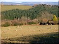
Across the Liverton Brook valley
From the track shown in Image] as it emerges from Pool Down Wood. The brook is out of sight just below. The double line of hedges marks the line of the road down the valley from Ilsington. The next hedge, across the sunlit triangle of field, is by the farm lane to Lenda.
Image: © Derek Harper
Taken: 4 Mar 2006
0.14 miles
6
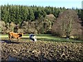
Muddy field in the Liverton Brook valley
Image: © David Gearing
Taken: 18 Dec 2012
0.14 miles
7
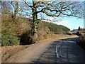
Road down Liverton Brook valley
The road between Ilsington and Liverton passes the foot of the green lane shown in Image On the slopes is the coniferous Pool Down Wood.
Image: © Derek Harper
Taken: 4 Mar 2006
0.14 miles
8
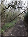
Track to Tipleyhill Cross in the valley of the Liverton Brook
The track curves to the left and crosses the brook before ascending the eastern side of the valley
Image: © David Smith
Taken: 16 Apr 2012
0.15 miles
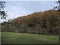
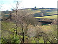
10

Trees near Pool Down Wood
A view from the road up the Liverton Brook valley. Pool Down Wood is in the background. The central tree with a purplish hue can only be an alder.
Image: © Derek Harper
Taken: 19 Jan 2023
0.18 miles