IMAGES TAKEN NEAR TO
Garners Close, NEWTON ABBOT, TQ12 6AY
Introduction
This page details the photographs taken nearby to Garners Close, TQ12 6AY by members of the Geograph project.
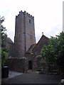
The Geograph project started in 2005 with the aim of publishing, organising and preserving representative images for every square kilometre of Great Britain, Ireland and the Isle of Man.

There are currently over 7.5m images from over14,400 individuals and you can help contribute to the project by visiting https://www.geograph.org.uk
Image Map
Images are licensed for reuse under creativecommons.org/licenses/by-sa/2.0
Notes
- Clicking on the map will re-center to the selected point.
- The higher the marker number, the further away the image location is from the centre of the postcode.
Image Listing (42 Images Found)
Images are licensed for reuse under creativecommons.org/licenses/by-sa/2.0
Image
Details
Distance
1
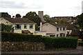
East Ogwell
A view of the village of East Ogwell looking towards the church tower.
Image: © Tony Atkin
Taken: 26 Sep 2009
0.05 miles
2
East Ogwell church
The church is dedicated to St Bartholomew
Image: © David Smith
Taken: 3 May 2011
0.05 miles
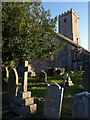
3
St Bartholomew's Church, East Ogwell
Image: © Roger Cornfoot
Taken: 11 Dec 2009
0.07 miles
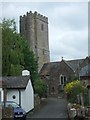
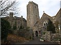
4
St Bartholomew's church, East Ogwell
A view of the north side of the church with its plain, battlemented tower.
Image: © Derek Harper
Taken: 30 Jun 2008
0.07 miles
5
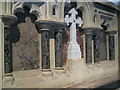
St Bartholomew's Church - reredos
The existence of an active and productive (East) Ogwell quarry Image in the area in Victorian times, probably gave rise to the creation of this wonderful reredos. Built with all the skill the masons possessed and with the local natural "Devonshire Marble", the marble columns and the inserted marble panels are set in what appears to be Beer stone from the quarries just outside the east Devon coastal village of Beer.
There are other examples in the church of the use of marble from the South Devon area ... it is worth looking around to see what can be found, but none so wonderful as the marble in the reredos at St. Bartholomew's Church at East Ogwell.
Image: © Colin Vosper
Taken: 22 Apr 2012
0.07 miles
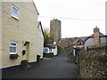
6
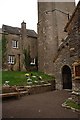
The Entrance to East Ogwell Church
Showing the south porch and the base of the church tower and houses unusually close to the tower.
Image: © Tony Atkin
Taken: 26 Sep 2009
0.07 miles
7
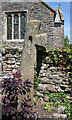
Old Wayside Cross at East Ogwell
East Ogwell Cross, a moved wayside cross with an old head, shaft and base. Set on the south side of the southern churchyard wall about 5 metres east of the churchyard gate of St Bartholomew church, East Ogwell in Ogwell parish.
Grade II Listed https://historicengland.org.uk/listing/the-list/list-entry/1249994.
See also http://www.flickr.com/photos/tollhouses/4728041377.
Milestone Society National ID: DVTE_OGG01
Image: © Alan Rosevear
Taken: 22 Jun 2010
0.07 miles
10
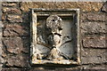
Skull and crossbones
Set high on the south wall of St Bartholomew's Church. The carving incorporates an hourglass representing the passing of time..
Image: © Guy Wareham
Taken: 22 Sep 2010
0.09 miles