IMAGES TAKEN NEAR TO
Torbryan, NEWTON ABBOT, TQ12 5UP
Introduction
This page details the photographs taken nearby to TQ12 5UP by members of the Geograph project.
The Geograph project started in 2005 with the aim of publishing, organising and preserving representative images for every square kilometre of Great Britain, Ireland and the Isle of Man.

There are currently over 7.5m images from over14,400 individuals and you can help contribute to the project by visiting https://www.geograph.org.uk
Image Map
Images are licensed for reuse under creativecommons.org/licenses/by-sa/2.0
Notes
- Clicking on the map will re-center to the selected point.
- The higher the marker number, the further away the image location is from the centre of the postcode.
Image Listing (40 Images Found)
Images are licensed for reuse under creativecommons.org/licenses/by-sa/2.0
Image
Details
Distance
1
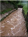
Race, Torbryan Mill
The Am Brook divides in two around the modern Torbryan Mill, and I think this is the mill stream, transformed into a brown torrent by heavy rain.
Image: © Derek Harper
Taken: 30 May 2008
0.03 miles
2
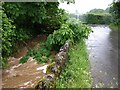
Am Brook at Poole Cross
This is just a few metres up the road from Image The stream, swollen with heavy rain, has just crossed under the road and threatens to overwhelm the branch of a horse chestnut. Poole Cross is in the background.
Image: © Derek Harper
Taken: 30 May 2008
0.06 miles
3
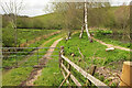
Track near Poole Cross
The private track is seen three years earlier at Image, and the view is not looking very different in spite of the changes detailed at Image But what I took to be a freshly-cut tree stump has no corresponding tree, so perhaps is a section of trunk from elsewhere. A family of Canada geese is along by the water's edge; see Image
Image: © Derek Harper
Taken: 9 May 2021
0.10 miles
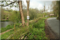
4
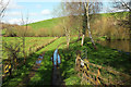
Track near Poole Cross
From the lane between Poole Cross and Torbryan, with one of the fishing ponds at Well Barn Farm on the right.
Image: © Derek Harper
Taken: 11 Apr 2018
0.10 miles
5
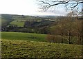
View from Orley Common
Looking across fields from woodland on the west side of the common, towards the Am Brook valley.
Image: © Derek Harper
Taken: 18 Dec 2009
0.10 miles
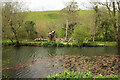
6
Path around the pond
As seen in Image] and Image], trees have been felled and bushes cut down around the southern pond at Well Barn Farm. There are several pairs of Canada geese here, at least one of them with goslings.
Image: © Derek Harper
Taken: 9 May 2021
0.11 miles
7

Canada geese by pond below Well Barn Farm
A closer view of the family glimpsed in Image
Image: © Derek Harper
Taken: 9 May 2021
0.11 miles
8
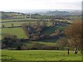
Am Brook valley
The valley at Poole Cross seen from Orley Common. The curving lane quickly crosses into Image
Image: © Derek Harper
Taken: 18 Dec 2009
0.12 miles
9
SLOW toads crossing
One of the remaining trees left after clearance has this sign. The relaid hedge seen in Image] and the stump across the pond seen in Image] also feature.
Image: © Derek Harper
Taken: 9 May 2021
0.12 miles
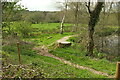
10
Pond, Well Barn Farm
As the brushwood seen in Image] suggests, there has been a fair bit of tree clearance here, and a tree stump and logs provide further evidence.
Image: © Derek Harper
Taken: 9 May 2021
0.13 miles