IMAGES TAKEN NEAR TO
Kingskerswell Road, NEWTON ABBOT, TQ12 5JU
Introduction
This page details the photographs taken nearby to Kingskerswell Road, TQ12 5JU by members of the Geograph project.
The Geograph project started in 2005 with the aim of publishing, organising and preserving representative images for every square kilometre of Great Britain, Ireland and the Isle of Man.

There are currently over 7.5m images from over14,400 individuals and you can help contribute to the project by visiting https://www.geograph.org.uk
Image Map
Images are licensed for reuse under creativecommons.org/licenses/by-sa/2.0
Notes
- Clicking on the map will re-center to the selected point.
- The higher the marker number, the further away the image location is from the centre of the postcode.
Image Listing (62 Images Found)
Images are licensed for reuse under creativecommons.org/licenses/by-sa/2.0
Image
Details
Distance
1
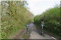
Cycle and pedestrian path
The path runs parallel to the Kingskerswell Road north west of Langford Bridge Farm.
Image: © John C
Taken: 22 Apr 2018
0.04 miles
2

Twin hedges by Kingskerswell Road
A view from the new dual use path that has taken over the old Kingskerswell Road, with a field access track formed between two hedges.
Image: © Derek Harper
Taken: 5 Jun 2015
0.05 miles
3
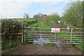
Private Property - Keep Out
Sign on the gate of farmland.
Image: © John C
Taken: 22 Apr 2018
0.05 miles
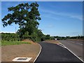
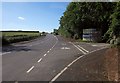
4

Kingskerswell Road
On the right, the former Kingskerswell Road is re-used as a new cycle and pedestrian pathway; on the left, a new road has been created as part of improvements relating to the new link road.
Image: © Derek Harper
Taken: 5 Jun 2015
0.05 miles
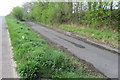
5
New path, Kingskerswell Road
In fact the new dual use path is veering off along the former line of Kingskerswell Road, now rebuilt to the right.
Image: © Derek Harper
Taken: 5 Jun 2015
0.06 miles
6
Cycle and pedestrian path - Kingskerswell Road
Image: © John C
Taken: 22 Apr 2018
0.06 miles
8
Kingskerswell Road
A reverse view of Image, with the old road on the right now converted to a cycle and footpath - see also Image On the extreme right is the entrance to Buckland Athletic Football Club on Homers Heath. The Toolstation reference is to the fact that the team play in the Toolstation Western League Premier Division.
Image: © Derek Harper
Taken: 5 Jun 2015
0.09 miles
9

Combined commerce and sporting interests
Access to Buckland Athletic FC and various commercial businesses.
Image: © John C
Taken: 22 Apr 2018
0.09 miles
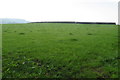
10
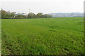
Langford Bridge Farm pasture
Looking northwards from a gate on the main road.
Image: © John C
Taken: 22 Apr 2018
0.10 miles