IMAGES TAKEN NEAR TO
Park Road, NEWTON ABBOT, TQ12 5BE
Introduction
This page details the photographs taken nearby to Park Road, TQ12 5BE by members of the Geograph project.
The Geograph project started in 2005 with the aim of publishing, organising and preserving representative images for every square kilometre of Great Britain, Ireland and the Isle of Man.

There are currently over 7.5m images from over14,400 individuals and you can help contribute to the project by visiting https://www.geograph.org.uk
Image Map
Images are licensed for reuse under creativecommons.org/licenses/by-sa/2.0
Notes
- Clicking on the map will re-center to the selected point.
- The higher the marker number, the further away the image location is from the centre of the postcode.
Image Listing (83 Images Found)
Images are licensed for reuse under creativecommons.org/licenses/by-sa/2.0
Image
Details
Distance
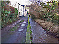
1
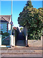
Alleyway to Park Road
This is the Cole's Lane end of a pedestrian alley connecting residential roads in Kingskerswell.
Image: © Richard Dorrell
Taken: 19 Jan 2011
0.02 miles
2

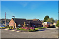
Park Inn, Kingskerswell
The pub is on Coles Lane, in the midst of a residential area some way from the centre of the village.
Image: © Derek Harper
Taken: 11 Dec 2008
0.04 miles
3
Retirement bungalows in Brookhaven Close
A small cul-de-sac of retirement bungalows managed by Anchor Housing, located off Cole's Lane.
Image: © Richard Dorrell
Taken: 19 Jan 2011
0.05 miles
5
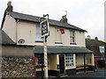
The Park Inn
Located in Cole's Lane - the pub stands within a quiet and predominantly residential district of Kingskerswell.
Image: © Richard Dorrell
Taken: 19 Jan 2011
0.06 miles
6
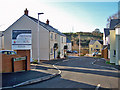
Lonsee Gardens, Kingskerswell
This is a new development of 2, 3 and 4 bedroom houses for Teign Housing, approached from a loop road named Carswells, in which there is older housing. From aerial photographs, it would appear that a pair of semi detached houses used to stand where this road enters the development.
Image: © Richard Dorrell
Taken: 19 Jan 2011
0.07 miles
7
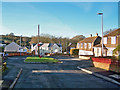
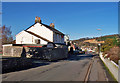
Carswells, Kingskerswell
There are tile hung fronts on the older houses in this unusually named residential road in Kingskerswell. The rendered houses beyond are part of a new development by Teign Housing. (See also Image] ).
Image: © Richard Dorrell
Taken: 19 Jan 2011
0.07 miles
8
Aller Brook
Here, the brook flows through a residential area of Kingskerswell on its way to join the River Teign at Newton Abbot.
Image: © Richard Dorrell
Taken: 19 Jan 2011
0.08 miles
9
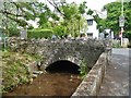
Over the brook
This small bridge carries School Road over Aller Brook.
Image: © Michael Dibb
Taken: 27 May 2019
0.10 miles
10
![Kingskerswell buildings [1]](https://s2.geograph.org.uk/geophotos/06/19/07/6190722_9589a13f_120x120.jpg)
Kingskerswell buildings [1]
Number 1 Coles Lane is late 17th century, altered in the 18th century and extended and modernised in the 20th century. Listed, grade II, with details at: https://historicengland.org.uk/listing/the-list/list-entry/1164911
Image: © Michael Dibb
Taken: 27 May 2019
0.10 miles