IMAGES TAKEN NEAR TO
Aller Mills, NEWTON ABBOT, TQ12 5AU
Introduction
This page details the photographs taken nearby to Aller Mills, TQ12 5AU by members of the Geograph project.
The Geograph project started in 2005 with the aim of publishing, organising and preserving representative images for every square kilometre of Great Britain, Ireland and the Isle of Man.

There are currently over 7.5m images from over14,400 individuals and you can help contribute to the project by visiting https://www.geograph.org.uk
Image Map
Images are licensed for reuse under creativecommons.org/licenses/by-sa/2.0
Notes
- Clicking on the map will re-center to the selected point.
- The higher the marker number, the further away the image location is from the centre of the postcode.
Image Listing (130 Images Found)
Images are licensed for reuse under creativecommons.org/licenses/by-sa/2.0
Image
Details
Distance
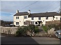
1
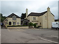
The Barn Owl, Kingskerswell
Public house with food. We enjoyed a nice lunch here but that's only our opinion.
Image: © Chris Allen
Taken: 1 Jun 2016
0.03 miles
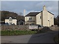
2
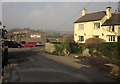
Aller Road at the Barn Owl
The Barn Owl is also shown in Image] and Image It was originally a C17 farmhouse http://list.english-heritage.org.uk/resultsingle.aspx?uid=1164848&searchtype=mapsearch . To the left is Aller Mills, home to a roofing business. Behind is the junction signpost shown in Image
Image: © Derek Harper
Taken: 5 Mar 2013
0.03 miles
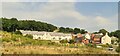
3
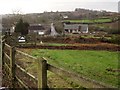
Buildings at Aller
Seen from the stretch of Aller Road shown in Image The road then passes between the houses to cross the railway line.
Image: © Derek Harper
Taken: 26 Jan 2013
0.03 miles
4
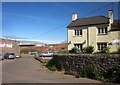
Barn Owl, Aller
Work has already started on the new link road when Image was taken two years earlier, but the landscape behind has been transformed, with two bridges being built across the railway.
Image: © Derek Harper
Taken: 5 Jun 2015
0.03 miles
5
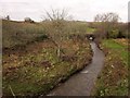
Aller Brook
Looking downstream from Aller Road to where the brook runs beneath the Paignton - Newton Abbot railway line, with what seems to be a little orchard on the left. There used to be a footbridge at the slight bend.
Image: © Derek Harper
Taken: 26 Jan 2013
0.04 miles
6
The Barn Owl inn at Kingskerswell
The inn straddles the grid line, which runs to the left of the main building
Image: © David Smith
Taken: 17 Feb 2012
0.04 miles
7
The Barn Owl Inn, Kingskerswell
Old pub, new housing alongside
Image: © Chris Morgan
Taken: 20 Jul 2022
0.04 miles
8
The Barn Owl inn at Kingskerswell
The board beside the door announces that the inn has "Real Chefs" and "Real Food"
Image: © David Smith
Taken: 17 Feb 2012
0.04 miles
9
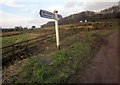
Signpost, Aller
A junction on Aller Road. Much felling of trees and hedges has taken place in the background (just over a gridline into Image), clearing the way for work to start of the new link road, which will join the old main road just up the hill.
Image: © Derek Harper
Taken: 21 Jan 2013
0.04 miles
10
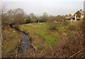
Aller Brook
Looking a little to the right of the line of view in Image, showing the recently-constructed house seen in Image
Image: © Derek Harper
Taken: 5 Mar 2013
0.04 miles