IMAGES TAKEN NEAR TO
Ridge Road, NEWTON ABBOT, TQ12 4EU
Introduction
This page details the photographs taken nearby to Ridge Road, TQ12 4EU by members of the Geograph project.
The Geograph project started in 2005 with the aim of publishing, organising and preserving representative images for every square kilometre of Great Britain, Ireland and the Isle of Man.

There are currently over 7.5m images from over14,400 individuals and you can help contribute to the project by visiting https://www.geograph.org.uk
Image Map
Images are licensed for reuse under creativecommons.org/licenses/by-sa/2.0
Notes
- Clicking on the map will re-center to the selected point.
- The higher the marker number, the further away the image location is from the centre of the postcode.
Image Listing (11 Images Found)
Images are licensed for reuse under creativecommons.org/licenses/by-sa/2.0
Image
Details
Distance
1
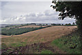
Harvest home
Corn crops in undulating fields north of Torquay have been harvested and the straw tidied up into bales ready for collection.
Image: © Richard Dorrell
Taken: 13 Sep 2015
0.08 miles
2
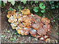
Fungi near Dunston
If it wasn't for the mould, they could almost be mistaken for a generous helping of crêpes vonnassiennes. This is on a green lane / route with public access that used to be part of the John Musgrave Heritage Trail Image; when you reach the lower section Image you appreciate why it's been diverted.
Image: © Derek Harper
Taken: 10 Oct 2020
0.09 miles
3
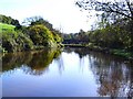
Fishing pool - South Devon
This quiet pool lies between Lower and Middle Rocombe. The surrounding area is surprisingly secluded.
Image: © Richard Knights
Taken: 20 Nov 2005
0.14 miles
4
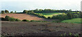
Head of Haccombe valley
Looking from Ridge Road across to Great Wood and Deer Park Lane.
Image: © Derek Harper
Taken: 12 Nov 2006
0.17 miles
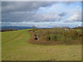
5
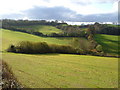
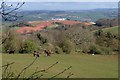
Southwest from Ridge Road
Fields and woods above Haccombe.
Image: © Derek Harper
Taken: 10 Oct 2020
0.17 miles
6
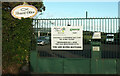
Notices at Mount Olive Ministries
I'm somewhat taken aback by the tenor of the notices on the gate to "part of God's church in Torbay" http://www.mountolive.org.uk/ . What about The Lord's Prayer? I suppose trespassers might regret being roped in to something they hadn't bargained for.
Image: © Derek Harper
Taken: 10 Oct 2020
0.20 miles
7
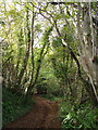
Deer Park Lane
This tree-lined green lane links the main Barton-Milber lane with Ridge Road near Haccombe Cross.
Image: © Derek Harper
Taken: 12 Nov 2006
0.20 miles
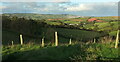
8
Field beside Deer Park Lane
Horses graze in an irregularly-shaped field on the hillside north of the green (muddy) lane. The view beyond is across Haccombe and the round hill with the ploughed fields to the far side of the Teign estuary, with Wear Farm caravan site prominent.
Image: © Derek Harper
Taken: 10 Apr 2008
0.21 miles
9
Ridge Road
The winding lane between the Haccombe and Rocombe valleys links the Newton-Torquay ridge lane to the lane along the southern edge of the Teign estuary, but only for walkers, bikes and possibly 4x4s, otherwise the farm on the right marks the end.
Image: © Derek Harper
Taken: 12 Nov 2006
0.21 miles
10
Tree guards near Mount Olive
This is, in part, the view seen in Image and Image, in low autumn afternoon sun. In the distance is some of Teignmouth.
Image: © Derek Harper
Taken: 10 Oct 2020
0.24 miles