IMAGES TAKEN NEAR TO
Kingsteignton, NEWTON ABBOT, TQ12 3PS
Introduction
This page details the photographs taken nearby to TQ12 3PS by members of the Geograph project.
The Geograph project started in 2005 with the aim of publishing, organising and preserving representative images for every square kilometre of Great Britain, Ireland and the Isle of Man.

There are currently over 7.5m images from over14,400 individuals and you can help contribute to the project by visiting https://www.geograph.org.uk
Image Map
Images are licensed for reuse under creativecommons.org/licenses/by-sa/2.0
Notes
- Clicking on the map will re-center to the selected point.
- The higher the marker number, the further away the image location is from the centre of the postcode.
Image Listing (57 Images Found)
Images are licensed for reuse under creativecommons.org/licenses/by-sa/2.0
Image
Details
Distance
1

Entry from Sandygate to Abbrook Park Bowling Club and Abbrook Farm, Kingsteignton
Image: © Robin Stott
Taken: 26 Apr 2022
0.04 miles
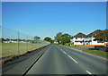
2

South on Sandygate, Kingsteignton
Over the hedge are signs of sports facilities, to do with Abbrook Park Bowling Club perhaps. Beyond, industry.
Image: © Robin Stott
Taken: 26 Apr 2022
0.06 miles
3
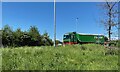
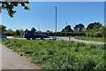
Wagon at the B3193 Clay Pits Way junction, Kingsteignton
One of the Evans Transport fleet heads south with a covered load – perhaps clay products for loading on to a waiting ship at Teignmouth. This is a frequently-observed journey by the many heavy haulage companies in the area.
Image: © Robin Stott
Taken: 26 Apr 2022
0.06 miles
5
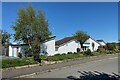
Kingsteignton Swimming Pool
It is a 25-metre heated outdoor pool https://kingsteigntonswimmingpool.org.uk There is vehicle access from both Meadowcroft Drive and Sandygate.
Image: © Robin Stott
Taken: 26 Apr 2022
0.07 miles
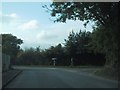
6
The Clay Pits Way junction from Lower Sandygate, Kingsteignton
Image: © Robin Stott
Taken: 26 Apr 2022
0.07 miles
7

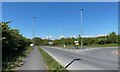
North on Sandygate, Kingsteignton
Ahead is the roundabout giving access to the rerouted B3193 Clay Pits Way, opened (according to the SABRE website) in November 2014. Other roads accessed are Strap Lane and Lower Sandygate.
Image: © Robin Stott
Taken: 26 Apr 2022
0.07 miles
8
Southern end of B3193 Clay Pits Way, Kingsteignton
The splash of yellow in the distance is flowering gorse atop a hill of quarry waste.
Image: © Robin Stott
Taken: 26 Apr 2022
0.09 miles
9
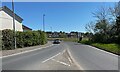
East on Strap Lane, Kingsteignton
Behind the camera is the roundabout at the Clay Pits Way junction. Ahead is Five Lanes Playing Field.
Image: © Robin Stott
Taken: 26 Apr 2022
0.09 miles