IMAGES TAKEN NEAR TO
Oakymead Park, Newton Road, NEWTON ABBOT, TQ12 3AN
Introduction
This page details the photographs taken nearby to Oakymead Park, Newton Road, TQ12 3AN by members of the Geograph project.
The Geograph project started in 2005 with the aim of publishing, organising and preserving representative images for every square kilometre of Great Britain, Ireland and the Isle of Man.

There are currently over 7.5m images from over14,400 individuals and you can help contribute to the project by visiting https://www.geograph.org.uk
Image Map
Images are licensed for reuse under creativecommons.org/licenses/by-sa/2.0
Notes
- Clicking on the map will re-center to the selected point.
- The higher the marker number, the further away the image location is from the centre of the postcode.
Image Listing (97 Images Found)
Images are licensed for reuse under creativecommons.org/licenses/by-sa/2.0
Image
Details
Distance
1
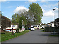
Park homes, Oakymead Park
Park homes is a common euphemism for permanently-sited residential caravans. The view is from the bridge over the unnamed stream by the Newton Road.
Image: © Robin Stott
Taken: 8 May 2012
0.01 miles
2
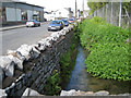
Unnamed stream below Oakymead Park
There seems a strong possibility that this is a former mill stream. Old maps show a Higher Mill to the north, apparently on the course. It may be fed from a water body called Well Head at SX87337376 in the Rydon area. This is one of a number of streams through the village and its extensive suburbs; they eventually join the River Teign.
Image: © Robin Stott
Taken: 8 May 2012
0.04 miles
3
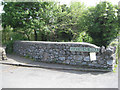
Bridge parapet, Oakymead Park
Built of (or faced with) the grey Devonian limestone rubble. The bridge crosses an unnamed stream at the entrance to Oakymead Park, a residential caravan site off the Newton Road.
Image: © Robin Stott
Taken: 8 May 2012
0.04 miles
4

Kingsteignton Retail Park
Also shown in Image Beside Costa is Home Bargains. What more could you possibly want?
Image: © Derek Harper
Taken: 21 Feb 2015
0.05 miles
5
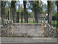
Playing field seen from Newton Road
It's hard to tell from old maps what's happened here. The land beyond was once a field opposite the vanished Oakford Farm but is now a playing field that seems to be attached to the primary school. The tree trunks are of the Lombardy poplars in Image
Image: © Robin Stott
Taken: 8 May 2012
0.05 miles
6
Unnamed stream above Oakymead Park
There seems a strong possibility that this is a former mill stream. Old maps show a Higher Mill to the north, apparently on the course. It may be fed from a water body called Well Head at SX87337376 in the Rydon area. Newton Road and the Lidl store, left.
Image: © Robin Stott
Taken: 8 May 2012
0.05 miles
7
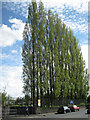
Lombardy Poplars, Newton Road
They're planted on the bank of an unnamed stream on the western side of a playing field. The view is from near the Lidl store.
Image: © Robin Stott
Taken: 8 May 2012
0.05 miles
8

Kingsteignton Retail Park
Another view of Costa and Home Bargains, shown from the other direction in Image
Image: © Derek Harper
Taken: 21 Feb 2015
0.05 miles
9
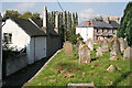
Church Street from Kingsteignton Church Yard
The churchyard is raised some six to ten feet above the road behind it.
Image: © Tony Atkin
Taken: 18 Sep 2008
0.06 miles
10

Kingsteignton Retail Park
Considerable revamped a few years ago. Here are Costa, and Pets at Home. Well, okay, if they were at home they wouldn't be here ...
Image: © Derek Harper
Taken: 21 Feb 2015
0.06 miles