IMAGES TAKEN NEAR TO
Church View, NEWTON ABBOT, TQ12 3AG
Introduction
This page details the photographs taken nearby to Church View, TQ12 3AG by members of the Geograph project.
The Geograph project started in 2005 with the aim of publishing, organising and preserving representative images for every square kilometre of Great Britain, Ireland and the Isle of Man.

There are currently over 7.5m images from over14,400 individuals and you can help contribute to the project by visiting https://www.geograph.org.uk
Image Map
Images are licensed for reuse under creativecommons.org/licenses/by-sa/2.0
Notes
- Clicking on the map will re-center to the selected point.
- The higher the marker number, the further away the image location is from the centre of the postcode.
Image Listing (78 Images Found)
Images are licensed for reuse under creativecommons.org/licenses/by-sa/2.0
Image
Details
Distance
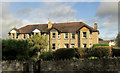
1
Houses on Vicarage Hill, Kingsteignton
To the west of those shown in Image
Image: © Derek Harper
Taken: 28 Sep 2019
0.06 miles
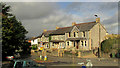
2
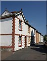
Houses on Vicarage Hill, Kingsteignton
A terrace of four by the roundabout junction with Greenhill Way.
Image: © Derek Harper
Taken: 28 Sep 2019
0.08 miles
3
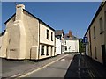
Fore Street, Kingsteignton
The first two houses on the left are originally C15: "The original circa late C15 house was of 3-room plan, the 2 right-hand rooms now occupied by No 51 and the narrow left-hand room is part of No 49. It was originally open to the roof throughout. In about C16 a floor was inserted over the right hand room jettied into the still open hall (central room). Later, probably in C17 the left hand room and hall were floored when a rear lateral stack was built to heat the hall." http://www.imagesofengland.org.uk/Details/Default.aspx?id=85419&mode=adv
Image: © Derek Harper
Taken: 23 Jun 2009
0.10 miles
4
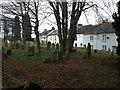
Graveyard of St Michael's Church, Kingsteignton
Looking towards cottages in Sandpath Road. The graveyard is raised by around 10 feet above the adjacent road, reflecting its continued use for over 500 years.
Image: © David Gearing
Taken: 23 Feb 2012
0.10 miles
5
Houses on Sandpath Road, Kingsteignton
Image: © Derek Harper
Taken: 23 Jun 2009
0.11 miles
6
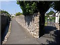
Berry Lane, Kingsteignton
On the left of the walled path is Image See also Image Through the gate on the right is Kingsteignton Bowling Club.
Image: © Derek Harper
Taken: 23 Jun 2009
0.12 miles
7
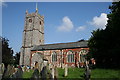
Kingsteignton Church
The different colours of the church is the result of different parts of the church being built of grey limestone and red sandstone.
Image: © Tony Atkin
Taken: 18 Sep 2008
0.12 miles
8
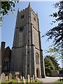
St Michael's church, Kingsteignton
The "tall grey west tower .. probably .. C17" (Cherry & Pevsner) of Image seen from the path crossing the churchyard beside the leat. But http://www.imagesofengland.org.uk/Details/Default.aspx?id=85371&mode=adv says that "the surviving medieval fabric (west tower and arcades), is C15 Perpendicular." The church was largely rebuilt in 1865.
Image: © Derek Harper
Taken: 23 Jun 2009
0.12 miles
9
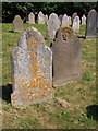
Gravestones, Kingsteignton (2)
Image: © Derek Harper
Taken: 23 Jun 2009
0.12 miles
10
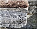
Ordnance Survey Cut Mark
This OS cut mark can be found on the SW angle of St Michael's Church. It marks a point 10.470m above mean sea level.
Image: © Adrian Dust
Taken: 25 Mar 2019
0.12 miles