IMAGES TAKEN NEAR TO
Valerian Place, NEWTON ABBOT, TQ12 1UX
Introduction
This page details the photographs taken nearby to Valerian Place, TQ12 1UX by members of the Geograph project.
The Geograph project started in 2005 with the aim of publishing, organising and preserving representative images for every square kilometre of Great Britain, Ireland and the Isle of Man.

There are currently over 7.5m images from over14,400 individuals and you can help contribute to the project by visiting https://www.geograph.org.uk
Image Map
Images are licensed for reuse under creativecommons.org/licenses/by-sa/2.0
Notes
- Clicking on the map will re-center to the selected point.
- The higher the marker number, the further away the image location is from the centre of the postcode.
Image Listing (16 Images Found)
Images are licensed for reuse under creativecommons.org/licenses/by-sa/2.0
Image
Details
Distance
1
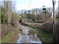
A low point on Howton Road
Daracombe Beacon can be seen through the trees.
Image: © Robin Stott
Taken: 19 Feb 2010
0.03 miles
2
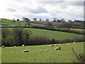
Ewes and lambs by Howton Road
Near Mile End, Newton Abbot.
The A383 runs along the hillside. The three black dots, extreme right, are golfers enjoying pay-and-play at Hele Park.
Image: © Robin Stott
Taken: 19 Feb 2010
0.06 miles
3
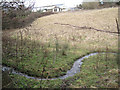
A winding channel below Moorpark
This is the outflow from a stream-fed water hazard on Hele Park golf course across the road.
Image: © Robin Stott
Taken: 19 Feb 2010
0.08 miles
5
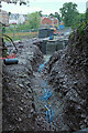
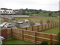
Trench by Howton Road
Leading into the new Hele Park estate occupying the site of Hele Park golf course, with houses on Cranesbill Way visible.
Image: © Derek Harper
Taken: 29 Jun 2021
0.13 miles
6
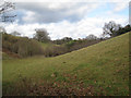
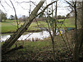
A small valley near Moorpark
The hilltop, centre, is southeast of Perry Farm.
Image: © Robin Stott
Taken: 19 Feb 2010
0.14 miles
7
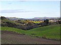
East of Seale Hayne - Devon
Looking east towards Newton Abbot and the Teign estuary. Excellent farmland in this area.
Image: © Richard Knights
Taken: 4 Dec 2005
0.16 miles
8
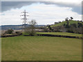
Clay waste near Moorpark
The level grey area beyond the pylon is waste from the Ringslade clay quarry. On the right one of the houses at Moorpark nestles below the nursery rhyme-perfect hill-shape of Daracombe Beacon.
Image: © Robin Stott
Taken: 19 Feb 2010
0.16 miles
9
Newton Abbott : Hele Park
Looking out across Hele Park in Newton Abbott.
Image: © Lewis Clarke
Taken: 23 Jun 2016
0.21 miles
10
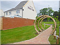
Newton Abbott : Hele Park
A residential development on the outskirts of Newton Abbott.
Image: © Lewis Clarke
Taken: 23 Jun 2016
0.21 miles