IMAGES TAKEN NEAR TO
Coombeshead Road, NEWTON ABBOT, TQ12 1PY
Introduction
This page details the photographs taken nearby to Coombeshead Road, TQ12 1PY by members of the Geograph project.
The Geograph project started in 2005 with the aim of publishing, organising and preserving representative images for every square kilometre of Great Britain, Ireland and the Isle of Man.

There are currently over 7.5m images from over14,400 individuals and you can help contribute to the project by visiting https://www.geograph.org.uk
Image Map
Images are licensed for reuse under creativecommons.org/licenses/by-sa/2.0
Notes
- Clicking on the map will re-center to the selected point.
- The higher the marker number, the further away the image location is from the centre of the postcode.
Image Listing (18 Images Found)
Images are licensed for reuse under creativecommons.org/licenses/by-sa/2.0
Image
Details
Distance
2
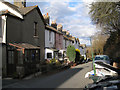
The very top of Pitt Hill Road
At its junction with Highweek Village.
Image: © Robin Stott
Taken: 19 Feb 2010
0.15 miles
3
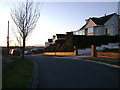
Hill Park Road, Highweek
Well-placed to enjoy the sunset – on a hill that became a Victorian suburb and subsequently a 20th century one.
Image: © Robin Stott
Taken: 20 Feb 2010
0.15 miles
4
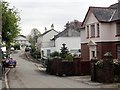
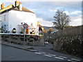
Highweek Village
The title Higweek Village both describes the place and is the street name although Highweek is no longer a village having been absorbed into Newton Abbot as the town expanded.
Image: © Tony Atkin
Taken: 15 Apr 2011
0.16 miles

7
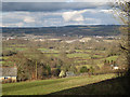
View of the Bovey Basin from Whitehill Road (3/3)
Looking northeast over Higher Loady Park from below the cottages Image
In the middle distance are floodmeadows on the west bank of the Teign, crossed by the racetrack which is the old Exeter Road. In the centre of the photo, hidden by trees, is Teign Bridge. Left of centre is a mound of clay waste being formed on the east side of Denistone Quarry Image, with a wooded mound of old waste appearing to its left Image Clay waste stretches away to the north.
Right of centre the Broadway clay pit is being filled, with a big shaped mound to its right. Beyond it at some distance is Higher Sandygate Image, mostly. Between the mounds in the centre of the photo is the narrow wooded cleft which marks the course of the Abb Brook or Abbrook which, in its upper reaches, is the Ugbrooke Stream Image
Image: © Robin Stott
Taken: 19 Feb 2010
0.18 miles
8

View of the Bovey Basin from Whitehill Road (2/3)
Looking just east of north over Higher Loady Park from below the cottages Image
Noticeable on the left is the top of the tower of Teigngrace church in Image The pale ground above it is the clay waste mound being formed on the Rixey Park (provisional name) quarry site, mostly in Image The huge Southacre Quarry disappears below it and behind the yellow-green land, which is a grassed mound of clay waste northwest of Preston. The River Teign runs left to right at its foot. The bright strip above it is clay waste at the back of the aptly-named White Pit Quarry. Also visible are the blue-green clay sheds strung along the B3193. These features alone fill Image
Nearer the camera, centre, are the houses at Mount Pleasant Image, another good vantage point for trying to understand this disrupted landscape. At close quarters much of it is hidden by trees and bunds.
Image: © Robin Stott
Taken: 19 Feb 2010
0.18 miles
9

View of the Bovey Basin from Whitehill Road (1/3)
Looking over Higher Loady Park from just below the cottages Image Running across the picture is Greycoat Lane. On the left among trees are the schools' playing fields at Forches Cross. The houses in Greycoat Lane have as a neighbour the Cremtor animal cremation facility, with the twin chimneys. The conifer plantation across the road hides the Stover clay quarry. All these features are in Image
The plume of steam is from the Candy tile factory at Heathfield Image The low pale shape above the plantation is the hill of clay waste north of Brocks Farm Image and three other squares. To its right is the Newbridge clay quarry Image and the edge of Chudleigh Knighton.
Image: © Robin Stott
Taken: 19 Feb 2010
0.18 miles