IMAGES TAKEN NEAR TO
Back Road, NEWTON ABBOT, TQ12 1FY
Introduction
This page details the photographs taken nearby to Back Road, TQ12 1FY by members of the Geograph project.
The Geograph project started in 2005 with the aim of publishing, organising and preserving representative images for every square kilometre of Great Britain, Ireland and the Isle of Man.

There are currently over 7.5m images from over14,400 individuals and you can help contribute to the project by visiting https://www.geograph.org.uk
Image Map
Images are licensed for reuse under creativecommons.org/licenses/by-sa/2.0
Notes
- Clicking on the map will re-center to the selected point.
- The higher the marker number, the further away the image location is from the centre of the postcode.
Image Listing (264 Images Found)
Images are licensed for reuse under creativecommons.org/licenses/by-sa/2.0
Image
Details
Distance
2
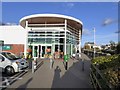
Asda, Newton Abbot
The new superstore that dominates the western end of the town centre. The River Lemon flows in the channel between the limestone walls to the left.
Image: © Derek Harper
Taken: 5 Nov 2006
0.02 miles
3
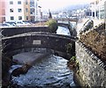
Union Bridge
This is the old Union Bridge (1822) which crosses the River Lemon in front of the new Asda supermarket building in Newton Abbot. The River Lemon is 16km long. Its source is on the south east side of Dartmoor near Haytor, it then joins with the River Sig and the Langworthy Brook at Sigford, passes the village of Bickington. Lower down it is joined by the Kestor Brook and then it flows through the woods in Bradley Valley passing the manor house. It is after this that it flows through Newton Abbot, passing through a 400 metre long tunnel below the town centre. Just below the town the river joins the River Teign near the head of its estuary.
Image: © Anthony Volante
Taken: 13 Jan 2010
0.02 miles
4
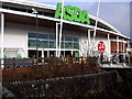
New Asda
This photo was taken beside the old Union Bridge (1822) which crosses the River Lemon in front of the new Asda supermarket building in Newton Abbot.
Image: © Anthony Volante
Taken: 13 Jan 2010
0.02 miles
5
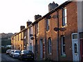
Grafton Road, Newton Abbot
Like Image, a short street of industrial housing running at right angles between Totnes Road and the River Lemon.
Image: © Derek Harper
Taken: 7 May 2008
0.03 miles
6
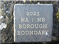
Commemorative Marker on Union Bridge, Newton Abbot
Commemorative Marker fixed to the parapet of Union Bridge, River Lemon. Now a footbridge from a car park leading to the Asda store. Newton Abbot parish. Inscribed 2023 / NA (vertical line) NB / BOROUGH / BOUNDARY, the plaque marks the 200th anniversary of the bridge and the former boundary between Newton Abbot and Newton Bushel boroughs.
Milestone Society National ID: DV_NABBOT01cm
Image: © T Jenkinson
Taken: 2 Jan 2024
0.03 miles
7
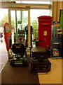
Newton Abbot: postbox № TQ12 7, within ASDA
A modern postbox of the style often seen in supermarkets nowadays. It is emptied finally at 5:30pm on weekdays and at 11am on Saturdays.
Image: © Chris Downer
Taken: 26 Aug 2009
0.04 miles
8
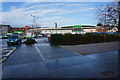
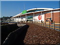
Asda and parking area
Looking across the bus lane.
Image: © jeff collins
Taken: 2 Jan 2014
0.04 miles
9
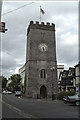
St Leonards Tower, Newton Abbot
This local landmark dates back to the Cromwell era when William of Orange arrived in South Devon. It is the site of many annual activities including the town crier championships which attracts some interesting characters from across the country. A great day out for photographers!!
Image: © Mike Crowe
Taken: 4 Jun 2005
0.04 miles
10
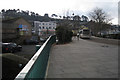
Highweek Way, Newton Abbot
A new road laid out across the frontage of the Asda supermarket and its car park. Seen from a crossing of the River Lemon and looking towards Wolborough Hill.
Image: © Robin Stott
Taken: 5 Jan 2010
0.04 miles