IMAGES TAKEN NEAR TO
Deancombe, BUCKFASTLEIGH, TQ11 0NA
Introduction
This page details the photographs taken nearby to TQ11 0NA by members of the Geograph project.
The Geograph project started in 2005 with the aim of publishing, organising and preserving representative images for every square kilometre of Great Britain, Ireland and the Isle of Man.

There are currently over 7.5m images from over14,400 individuals and you can help contribute to the project by visiting https://www.geograph.org.uk
Image Map
Images are licensed for reuse under creativecommons.org/licenses/by-sa/2.0
Notes
- Clicking on the map will re-center to the selected point.
- The higher the marker number, the further away the image location is from the centre of the postcode.
Image Listing (23 Images Found)
Images are licensed for reuse under creativecommons.org/licenses/by-sa/2.0
Image
Details
Distance
1
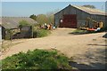
Farm buildings at Addislade
Another view of some of the barns shown in Image The public access route from across the Addislade Water valley runs past them on the right.
Image: © Derek Harper
Taken: 8 Apr 2017
0.03 miles
2
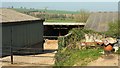
Farm buildings at Addislade
From the route with public access past the farm.
Image: © Derek Harper
Taken: 8 Apr 2017
0.03 miles
3
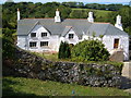
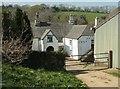
Addislade
This C17 farmhouse http://www.britishlistedbuildings.co.uk/en-99254-addislade-dean-prior-devon#.Vj8r1l7ztuQ has a scantle roof, a rare survival, and this has just been completely restored by the owner with grant help from English Heritage. Opened to the public on Heritage Open Day 2006. (http://www.addislade.deanprior.com - the site included a detailed survey of the building but is unfortunately no longer available. http://www.theguardian.com/artanddesign/2015/apr/07/david-norrish-obituary includes some detail of the restoration).
Image: © Derek Harper
Taken: 9 Sep 2006
0.05 miles
4
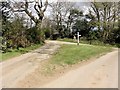
Butts Cross
A typical rural junction near Nurston with a triangle of grass at the centre.
Image: © Tony Atkin
Taken: 8 Apr 2012
0.05 miles
5
Addislade
Image, taken on Heritage Open Day on 2006, is a rather clearer image of this fine grade II* listed farmhouse, described at http://www.britishlistedbuildings.co.uk/101325409-addislade-dean-prior#.Vj8r1l7ztuQ .
Image: © Derek Harper
Taken: 8 Apr 2017
0.05 miles
6
Addislade
Seen from the lane between Deancombe and Reddacleave Kiln Cross. It can be seen much more clearly at https://www.geograph.org.uk/gridref/SX7164?centi=SX715640 .
Image: © Derek Harper
Taken: 1 Sep 2022
0.06 miles
7
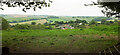
Field near Addisdale
An assortment of steel gates guards the entrance to this field from the route with public access near Butts Cross. Below are buildings at Nurston.
Image: © Derek Harper
Taken: 8 Apr 2017
0.08 miles
8
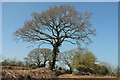
Tree near Addislade
One tree has survived along the hedgebank shown in Image Beyond, Dean Prior Footpath 2 meets the lane at Butts Cross.
Image: © Derek Harper
Taken: 8 Apr 2017
0.08 miles
9
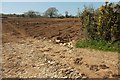
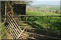
Field near Addisdale
The arable field across the hedgebank in Image The trees are along the lane between Nurston and Moor Cross.
Image: © Derek Harper
Taken: 8 Apr 2017
0.11 miles
10
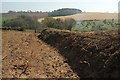
Hedgebank above Moorshead Brook
Another denuded hedgebank, on the opposite side of the gateway from whiuch Image] was taken from the stretch shown in Image] and Image
Image: © Derek Harper
Taken: 8 Apr 2017
0.14 miles