IMAGES TAKEN NEAR TO
BUCKFASTLEIGH, TQ11 0HH
Introduction
This page details the photographs taken nearby to TQ11 0HH by members of the Geograph project.
The Geograph project started in 2005 with the aim of publishing, organising and preserving representative images for every square kilometre of Great Britain, Ireland and the Isle of Man.

There are currently over 7.5m images from over14,400 individuals and you can help contribute to the project by visiting https://www.geograph.org.uk
Image Map
Images are licensed for reuse under creativecommons.org/licenses/by-sa/2.0
Notes
- Clicking on the map will re-center to the selected point.
- The higher the marker number, the further away the image location is from the centre of the postcode.
Image Listing (3 Images Found)
Images are licensed for reuse under creativecommons.org/licenses/by-sa/2.0
Image
Details
Distance
2
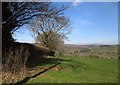
Towards Holne
Trees along a field boundary running away from the lane between Cross Furzes and Button. The ridgetop village of Holne is across the valleys of the Mardle and the Holy Brook. Prominent in the distance on the right is Hamel Down.
Image: © Derek Harper
Taken: 14 Mar 2013
0.21 miles
3
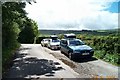
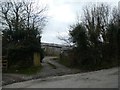
Cross Furzes, Buckfastleigh
Limited offroad parking for walkers doing the Abbot's way walk over Dartmoor.
Image: © Richard Knights
Taken: 28 May 2005
0.23 miles