IMAGES TAKEN NEAR TO
BUCKFASTLEIGH, TQ11 0FA
Introduction
This page details the photographs taken nearby to TQ11 0FA by members of the Geograph project.
The Geograph project started in 2005 with the aim of publishing, organising and preserving representative images for every square kilometre of Great Britain, Ireland and the Isle of Man.

There are currently over 7.5m images from over14,400 individuals and you can help contribute to the project by visiting https://www.geograph.org.uk
Image Map
Images are licensed for reuse under creativecommons.org/licenses/by-sa/2.0
Notes
- Clicking on the map will re-center to the selected point.
- The higher the marker number, the further away the image location is from the centre of the postcode.
Image Listing (14 Images Found)
Images are licensed for reuse under creativecommons.org/licenses/by-sa/2.0
Image
Details
Distance
1
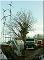
Travellers near Higher Beara Cross
With an intriguing collection of wind generators.
Image: © Derek Harper
Taken: 20 Dec 2020
0.02 miles
2
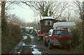
Travellers near Higher Beara Cross
On Staverton BOAT (Byway open to all traffic) 37.
Image: © Derek Harper
Taken: 20 Dec 2020
0.03 miles
3
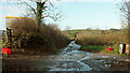
Approaching Higher Beara Cross
Staverton BOAT (Byway open to all traffic) 37 reaches its northern end in 25 metres, joining the lane up from Wash Cross, and reaching Higher Beara Cross in just over a further 100 metres.
Image: © Derek Harper
Taken: 20 Dec 2020
0.13 miles
4
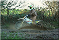
Motorbike on BOAT
Well, it is a byway open to all traffic (Staverton BOAT 37).
Image: © Derek Harper
Taken: 20 Dec 2020
0.13 miles
5
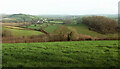
Countryside southwest of Woolston Green
Looking left from Image], and a wider view of the summer scene in Image, with Tor Hill Plantation on the right and Woolston Green left of centre.
Image: © Derek Harper
Taken: 20 Dec 2020
0.19 miles
6
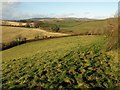
Approaching Higher Beara Cross
Staverton Bridleway 25 runs along the upper edge of this field on the upper slopes of the Dart valley.
Image: © Derek Harper
Taken: 5 Dec 2008
0.19 miles
7
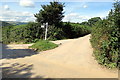
Staverton bridleway 25
The track leads southwards from Higher Beara Cross.
Image: © Derek Harper
Taken: 20 Dec 2020
0.20 miles
9
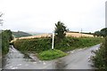
Higher Beara Cross
Another, winter, photo of Image The lane on the right, heading along the ridge towards High Beara and Five Lanes, was once the main road from Ashburton to Totnes. Green Lane, on the left, drops to the Dart valley.
Image: © Derek Harper
Taken: 5 Dec 2008
0.21 miles
10
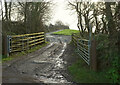
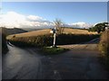
Green Lane Meets the Ridgetop Road
A minor road junction called Higher Beara Cross where the narrow road which runs steeply up the hillside reaches the top. A lot of construction traffic here has given the road a covering of reddish earth.
Image: © Tony Atkin
Taken: 26 Aug 2017
0.23 miles