IMAGES TAKEN NEAR TO
Dartbridge Manor, Dart Bridge Road, BUCKFASTLEIGH, TQ11 0EX
Introduction
This page details the photographs taken nearby to Dartbridge Manor, Dart Bridge Road, TQ11 0EX by members of the Geograph project.
The Geograph project started in 2005 with the aim of publishing, organising and preserving representative images for every square kilometre of Great Britain, Ireland and the Isle of Man.

There are currently over 7.5m images from over14,400 individuals and you can help contribute to the project by visiting https://www.geograph.org.uk
Image Map
Images are licensed for reuse under creativecommons.org/licenses/by-sa/2.0
Notes
- Clicking on the map will re-center to the selected point.
- The higher the marker number, the further away the image location is from the centre of the postcode.
Image Listing (213 Images Found)
Images are licensed for reuse under creativecommons.org/licenses/by-sa/2.0
Image
Details
Distance
1
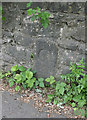
Old Bridge Marker by Dart Bridge Road, Buckfastleigh
Bridge Marker by the UC road, in parish of Buckfastleigh (Teignbridge District), 80m S of Dart Bridge, in wall, 15m South of Bus Stop.
Surveyed
Milestone Society National ID: DV_PLEX21br
Image: © Alan Rosevear
Taken: 3 May 2011
0.04 miles
3
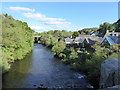
River Dart at Buckfastleigh
Looking downstream from Dart Bridge
Image: © Maurice D Budden
Taken: 13 May 2018
0.04 miles
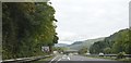
5
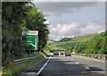
A38, Buckfastleigh
Approaching Buckfastleigh turnoff from the south.
Image: © Pierre Terre
Taken: 20 Jun 2009
0.07 miles
6
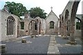
Buckfastleigh Church
This hilltop and isolated church was successfully destroyed by an arson attack in July 1992. Many say it was fired by witches. Certainly the church had an intense and lonely atmosphere - not least because it houses the grave of Richard Cabell, a hated and feared wicked landowner of the 17th century.
Image: © Richard Knights
Taken: Unknown
0.07 miles
7
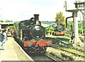
Buckfastleigh station and locos
Buckfastleigh - Totnes Preserved Railway
Image: © Chris Coleman
Taken: Unknown
0.07 miles
8
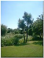
'Torbay' Palm
..taken at Buckfastleigh, at the South Devon Steam Railway.
Image: © Laura Whiting
Taken: 13 Jul 2005
0.07 miles
9
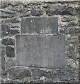
Old Bridge Marker by the B3380, Dart Bridge, Buckfastleigh
Bridge Marker by the B3380 (was A38), in parish of Buckfastleigh (Teignbridge District), Dart Bridge, half mile East of telephone kiosk, above path, built into bridge parapet, below older tablet, Southeast side of road. See Image for description of upper stone.
Inscription reads:-
County of Devon
DART BRIDGE
Reconstructed and widened
1929
Brian S Varer(?) | Frederick(?) Verren
...........Clerk | County Surveyor
Dart Bridge is Grade II Listed.
List Entry Number: 1280217 https://historicengland.org.uk/listing/the-list/list-entry/1280217
Milestone Society National ID: DV_PLEX21abr
Image: © Alan Rosevear
Taken: 3 May 2011
0.07 miles
10
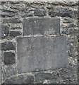
Old Commemorative Stone by the B3380, Dart Bridge, Buckfastleigh
Commemorative Marker by the B3380 (was A38), in parish of Buckfastleigh (Teignbridge District), Dart Bridge, half mile East of telephone kiosk, above path, built into bridge parapet. See Image for description of lower stone.
Inscription reads:-
WIDENED 1827
J GREEN ESQʳ. Archᵗ.
J BROWN BUILDER.
Dart Bridge is Grade II listed.
List Entry Number: 1280217 https://historicengland.org.uk/listing/the-list/list-entry/1280217
Surveyed
Milestone Society National ID: DV_PLEX21cm
Image: © Alan Rosevear
Taken: 3 May 2011
0.07 miles