IMAGES TAKEN NEAR TO
Abbey Grange Close, BUCKFASTLEIGH, TQ11 0EU
Introduction
This page details the photographs taken nearby to Abbey Grange Close, TQ11 0EU by members of the Geograph project.
The Geograph project started in 2005 with the aim of publishing, organising and preserving representative images for every square kilometre of Great Britain, Ireland and the Isle of Man.

There are currently over 7.5m images from over14,400 individuals and you can help contribute to the project by visiting https://www.geograph.org.uk
Image Map
Images are licensed for reuse under creativecommons.org/licenses/by-sa/2.0
Notes
- Clicking on the map will re-center to the selected point.
- The higher the marker number, the further away the image location is from the centre of the postcode.
Image Listing (158 Images Found)
Images are licensed for reuse under creativecommons.org/licenses/by-sa/2.0
Image
Details
Distance
1
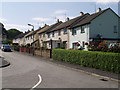
Furlong Close, Buckfast
A cul-de-sac off Mill Lane, behind the mill complex at Buckfast.
Image: © Derek Harper
Taken: 22 Aug 2007
0.09 miles
2
Monastic Produce Shop and Water Mill
Visitors and tourists are well catered for at Buckfast Abbey with a restaurant and a number of gift and book shops as well as the abbey itself. The monks are well known for bee keeping and honey is just one of the products that provides a good source of revenue in the Produce Shop. Unfortunately when we were there in July, the honey had sold out and we were told there wouldn't be any more until September. So if you want some get there early in the season.
Image: © Garth Newton
Taken: 19 Jul 2005
0.10 miles
4
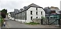
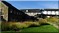
Buckfast - Higher Mill Lane
Industrial heritage - old woollen mill west of Buckfast Abbey.
Image: © Colin Smith
Taken: 25 Jul 2021
0.10 miles
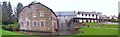
5
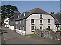
Higher Mill, Buckfast
Cherry & Pevsner write: "A complex of late C18 / early C19 woollen mills. The two and three storey stuccoed stone rubble buildings with slated upper floors under asbestos slate roofs were cottages, with the mill behind". The road is Mill Lane.
Image: © Derek Harper
Taken: 22 Aug 2007
0.10 miles
6
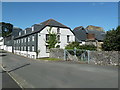
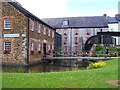
Higher Buckfast Mill
Restored early nineteenth century woollen mill. Note the chimney base. There is a new water wheel round the far side with a long supply launder.
Image: © Chris Allen
Taken: 31 Aug 2013
0.10 miles
8
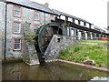
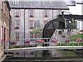
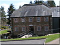
Upper Mill at Buckfast Abbey
An overshot water wheel supplied by an elevated mill race that powers this working mill.
Image: © Derek Voller
Taken: 16 Jun 2014
0.10 miles
9
Water Wheel, Buckfast Abbey
The water wheel at Buckfast Abbey is powered by water being diverted via a 'leat' from the River Dart. For a view of the Abbey refer to picture Image
Image: © Len Williams
Taken: 18 Dec 2015
0.11 miles