IMAGES TAKEN NEAR TO
New Road, BUCKFASTLEIGH, TQ11 0AJ
Introduction
This page details the photographs taken nearby to New Road, TQ11 0AJ by members of the Geograph project.
The Geograph project started in 2005 with the aim of publishing, organising and preserving representative images for every square kilometre of Great Britain, Ireland and the Isle of Man.

There are currently over 7.5m images from over14,400 individuals and you can help contribute to the project by visiting https://www.geograph.org.uk
Image Map
Images are licensed for reuse under creativecommons.org/licenses/by-sa/2.0
Notes
- Clicking on the map will re-center to the selected point.
- The higher the marker number, the further away the image location is from the centre of the postcode.
Image Listing (140 Images Found)
Images are licensed for reuse under creativecommons.org/licenses/by-sa/2.0
Image
Details
Distance
1
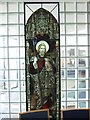
Stained Glass window inside St Luke's Church
St Luke's Church was opened in 2002 (see Image] for an exterior view) on the site of the earlier town centre chapel. This window in one of the interior glass partitions came from the older chapel.
Image: © David Smith
Taken: 21 Feb 2009
0.01 miles
2
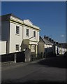
The John Loosemore Centre, Chapel Street, Buckfastleigh
The former Congregational chapel, now used for organ building and training of organists
Image: © David Smith
Taken: 5 Feb 2020
0.01 miles
3
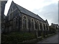
Two churches, Buckfastleigh
St Benedict's Roman Catholic church and the United Reformed church (see Image]) are side by side, a major contrast in architectural styles, on Chapel Street. The unlisted Catholic church dates from 1939, a "late but well crafted example of Arts & Crafts influenced design" http://www.dartmoor-npa.gov.uk/__data/assets/pdf_file/0011/42041/Buckfastleigh-web-quality-Key-buildings.pdf .
Image: © Derek Harper
Taken: 14 Mar 2013
0.02 miles
4
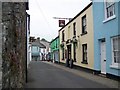
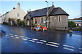
The White Hart, Buckfastleigh
The White Hart one side of the road and the Globe on the other side.
Image: © Maigheach-gheal
Taken: 13 May 2009
0.02 miles
5
United Reformed church, Buckfastleigh
Looking down Chapel Street, with the stuccoed church http://list.english-heritage.org.uk/resultsingle.aspx?uid=1209045&searchtype=mapsearch on the left. The railings and gates at the front are separately listed http://list.english-heritage.org.uk/resultsingle.aspx?uid=1292408&searchtype=mapsearch .
Image: © Derek Harper
Taken: 14 Mar 2013
0.02 miles
6
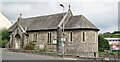
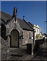
Buckfastleigh - St Benedict's Church
RC church on Chapel Street in the town centre of Buckfastleigh.
Image: © Colin Smith
Taken: 25 Jul 2021
0.02 miles
7
St Benedict's Catholic Church, Buckfastleigh
To the right next door is a Methodist Hall both situated on Chapel Street.
Image: © jeff collins
Taken: 10 Dec 2014
0.02 miles
8
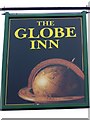
Sign for the Globe Inn, Buckfastleigh
The Globe has always been a popular pub sign. It was a one time associated with Portugal, and indicated that a tavern sold Portuguese wines.
Image: © Maigheach-gheal
Taken: 13 May 2009
0.03 miles
9
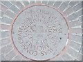
Commemorative stone outside St Luke's Church
St Luke's Church was opened in 2002 (see Image] for an exterior view) on the site of the earlier town centre chapel. This commemorative stone is in the paving at the main door.
Image: © David Smith
Taken: 21 Feb 2009
0.03 miles
10
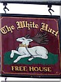
Sign for the White Hart, Buckfastleigh
This sign is a combination of heraldry and history. The White Hart was on Richard II's coat of arms and he could be a belligerent and aggressive sort of chap. An innkeeper who displayed this sign was saying 'Don't burn my inn, I'm on your side'. Such was the level of toadying at this time, that the name White Hart became synonymous with inns, and people continued using it longer after Richard II was gone and it is still used today.
Image: © Maigheach-gheal
Taken: 13 May 2009
0.03 miles