IMAGES TAKEN NEAR TO
Mardle Way, BUCKFASTLEIGH, TQ11 0AG
Introduction
This page details the photographs taken nearby to Mardle Way, TQ11 0AG by members of the Geograph project.
The Geograph project started in 2005 with the aim of publishing, organising and preserving representative images for every square kilometre of Great Britain, Ireland and the Isle of Man.

There are currently over 7.5m images from over14,400 individuals and you can help contribute to the project by visiting https://www.geograph.org.uk
Image Map
Images are licensed for reuse under creativecommons.org/licenses/by-sa/2.0
Notes
- Clicking on the map will re-center to the selected point.
- The higher the marker number, the further away the image location is from the centre of the postcode.
Image Listing (133 Images Found)
Images are licensed for reuse under creativecommons.org/licenses/by-sa/2.0
Image
Details
Distance
1
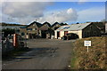
Woollen mill in Buckfastleigh
This fairly modern post 1945 style industrial building, see also Image is no longer used as a woollen mill by the Axminster Carpets group of companies. Behind what appears to be an office area can be seen the weaving sheds which would have housed the looms and other large machines. The building appears to be currently used to store products for the adjoining Devonia Sheepskins factory Image
Image: © Adrian Platt
Taken: 20 Jan 2009
0.02 miles
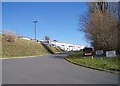
2
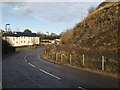
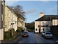
Mardle Way, Buckfastleigh
Mardle Way provides a route for traffic to avoid the narrow Market Street and Chapel Street, although it still leads into the town centre. Here, just north of the River Mardle, it passes a factory on its way up the hill towards Buckfast.
Image: © Derek Harper
Taken: 16 Jan 2009
0.03 miles
3
Devonia Sheepskins premises at Buckfastleigh
Seen across the yard are the premises of Devonia Products, part of the Axminster Carpets group of companies. The firm has been operating in Buckfastleigh for some 200 years, and its tannery produces a variety of sheepskin products from locally sourced lambskins - see http://www.devoniaproducts.co.uk .
Image: © Adrian Platt
Taken: 20 Jan 2009
0.05 miles
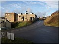
4
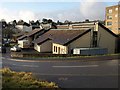
Mardle Way, Buckfastleigh
Image approaches the top of Church Street. As it passes Holne Court (the block on the left), the road becomes Holne Road.
Image: © Derek Harper
Taken: 16 Jan 2009
0.05 miles
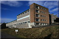
5
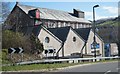
Newson Building, Buckfastleigh
Small commercial units occupy this building on Image
Image: © Derek Harper
Taken: 16 Jan 2009
0.05 miles
6
Former mill on Mardle Way
Known as Hamylyn House.
Image: © Fernweh
Taken: 15 Mar 2014
0.06 miles
7
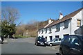
Sun Inn, Buckfastleigh
Jutting out across Bridge Street at its junction with Silver Street, the old pub seems to mark the conclusion of the town. A reverse view down the street is at Image
Image: © Derek Harper
Taken: 16 Jan 2009
0.07 miles
8
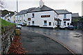
Sun Inn, Buckfastleigh
At the junction of Silver Street and Church Street.
Image: © jeff collins
Taken: 10 Dec 2014
0.07 miles