IMAGES TAKEN NEAR TO
North Huish, SOUTH BRENT, TQ10 9NQ
Introduction
This page details the photographs taken nearby to TQ10 9NQ by members of the Geograph project.
The Geograph project started in 2005 with the aim of publishing, organising and preserving representative images for every square kilometre of Great Britain, Ireland and the Isle of Man.

There are currently over 7.5m images from over14,400 individuals and you can help contribute to the project by visiting https://www.geograph.org.uk
Image Map
Images are licensed for reuse under creativecommons.org/licenses/by-sa/2.0
Notes
- Clicking on the map will re-center to the selected point.
- The higher the marker number, the further away the image location is from the centre of the postcode.
Image Listing (24 Images Found)
Images are licensed for reuse under creativecommons.org/licenses/by-sa/2.0
Image
Details
Distance
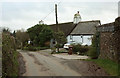
1
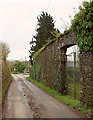
Gateway in wall, North Huish
The lane from Avonwick passes the grounds of Stoke Court. Down the lane is the listed Church House https://historicengland.org.uk/listing/the-list/list-entry/1227876 .
Image: © Derek Harper
Taken: 26 Nov 2019
0.02 miles
2
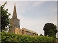
North Huish Church
"The dedication to St Mary may not be authentic" http://list.english-heritage.org.uk/resultsingle.aspx?uid=1108208&searchtype=mapsearch (a very thorough description) . The grade I listed church is "largely early C14, probably with earlier fabric". This view, like Image, is from the lane from Rectory Cross.
Image: © Derek Harper
Taken: 24 Jul 2014
0.02 miles
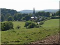
3
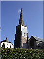
St Mary's Church, North Huish
This is the spire of St Mary's Church, North Huish, South of Avonwick in Devon. This church is now part of the Churches Conservation Trust and is in need of a lot of TLC http://www.visitchurches.org.uk/Ourchurches/Completelistofchurches/St-Marys-Church-North-Huish-Devon/.
Image: © David Neale
Taken: 9 Apr 2004
0.02 miles
5
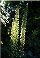
Wall Pennywort, North Huish
Umbilicus rupestris catching sunlight a few metres up the lane from Image
Image: © Derek Harper
Taken: 24 Jun 2009
0.03 miles
6
Church House, North Huish
"Probably a church house, now a private house. Probably early C17, possibly with C16 origins" https://historicengland.org.uk/listing/the-list/list-entry/1227876 .
Image: © Derek Harper
Taken: 26 Nov 2019
0.03 miles
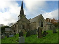
7
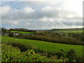
North Huish from the east
There's not a great deal of North Huish, and most of it is off to the left in this photo, dominated by Image and taken from the highest point on the Image, which is at the western end of the straight stretch.
Image: © Derek Harper
Taken: 24 Jun 2009
0.04 miles
8
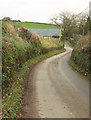
Lane, North Huish
Linking two parts of the disjointed hamlet. Ahead is Hillside Barn.
Image: © Derek Harper
Taken: 26 Nov 2019
0.11 miles
10
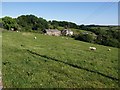
North Huish
Image: © Derek Harper
Taken: 24 Jun 2009
0.12 miles