IMAGES TAKEN NEAR TO
SOUTH BRENT, TQ10 9LW
Introduction
This page details the photographs taken nearby to TQ10 9LW by members of the Geograph project.
The Geograph project started in 2005 with the aim of publishing, organising and preserving representative images for every square kilometre of Great Britain, Ireland and the Isle of Man.

There are currently over 7.5m images from over14,400 individuals and you can help contribute to the project by visiting https://www.geograph.org.uk
Image Map
Images are licensed for reuse under creativecommons.org/licenses/by-sa/2.0
Notes
- Clicking on the map will re-center to the selected point.
- The higher the marker number, the further away the image location is from the centre of the postcode.
Image Listing (15 Images Found)
Images are licensed for reuse under creativecommons.org/licenses/by-sa/2.0
Image
Details
Distance
1
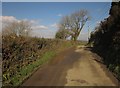
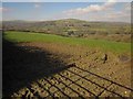
Lane to Marley Head
Passing the entrance to Marley Thatch Farm, with a tree at the end of a field boundary.
Image: © Derek Harper
Taken: 18 Feb 2013
0.08 miles
2
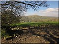
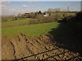
Pasture near The Cedars
The field to the north of Image], with the same field boundary, and a view across the A38 to Brent Hill in the National Park.
Image: © Derek Harper
Taken: 18 Feb 2013
0.09 miles
3
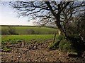
Pasture near The Cedars
The end of a field boundary running away from the lane between New Cross and Marley Head. The small valley runs down to join the Horse Brook, a tributary of the Avon.
Image: © Derek Harper
Taken: 18 Feb 2013
0.10 miles
4
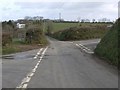
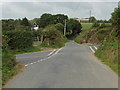
New Cross
A junction of lanes on high ground. Ahead is The Cedars; the lane past it leads to Marley Head. Left and right are for Stidston and Diptford respectively.
Image: © Derek Harper
Taken: 10 Mar 2009
0.11 miles
5
Field at New Cross
A view through the gate seen on the left of Image Only this corner of the field (which is also shown in Image]) is in square. On the horizon is Brent Hill (centre), on the edge of Dartmoor; Ugborough Moor rises on the left.
Image: © Derek Harper
Taken: 18 Feb 2013
0.12 miles
6
New Cross - crossroads near Stidson, South Brent
Image: © Ruth Sharville
Taken: 14 Sep 2014
0.12 miles
7
Field at New Cross
Looking to the right of Image] and, in effect, a detail of Image Again, only the nearer part of the field is in square; The Cedars is in Image
Image: © Derek Harper
Taken: 18 Feb 2013
0.13 miles
8
Clumpfield Plantation at Marley Head
Taken from Kerries Road in South Brent. The farm at the top right is Marley Thatch, with a mobile phone mast situated behind it, on what is one of the higher points locally that is not within the Dartmoor National Park where such masts are rarely approved.
Also visible is the line of electricity pylons that follow the line of the A38 dual carriageway between Marley Head and Ivybridge. The A38 is out of sight here in the valley in front of the pylons and could not be heard this day as there was so little traffic, although its presence is usually given away by the constant background roar of traffic.
Image: © Adrian Platt
Taken: 18 Dec 2010
0.15 miles
9
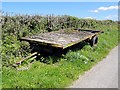
Abandoned Trailer
A farm trailer slowly rotting away on the roadside.
Image: © Tony Atkin
Taken: 12 May 2012
0.17 miles
10
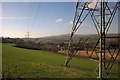
Farmland and pylons west of Marley Head
From the lane to New Cross, with the A38, South Brent, and Dartmoor in the background.
Image: © Derek Harper
Taken: 18 Feb 2013
0.17 miles