IMAGES TAKEN NEAR TO
Plymouth Road, SOUTH BRENT, TQ10 9HU
Introduction
This page details the photographs taken nearby to Plymouth Road, TQ10 9HU by members of the Geograph project.
The Geograph project started in 2005 with the aim of publishing, organising and preserving representative images for every square kilometre of Great Britain, Ireland and the Isle of Man.

There are currently over 7.5m images from over14,400 individuals and you can help contribute to the project by visiting https://www.geograph.org.uk
Image Map
Images are licensed for reuse under creativecommons.org/licenses/by-sa/2.0
Notes
- Clicking on the map will re-center to the selected point.
- The higher the marker number, the further away the image location is from the centre of the postcode.
Image Listing (66 Images Found)
Images are licensed for reuse under creativecommons.org/licenses/by-sa/2.0
Image
Details
Distance
1
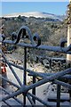
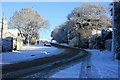
Garden gate in Plymouth Road, South Brent
Looking over the Avon Valley to Ugborough Beacon (in SX6659).
Image: © Adrian Platt
Taken: 18 Dec 2010
0.02 miles
2
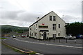
London Inn
On the B3372 in the village of South Brent.
Image: © jeff collins
Taken: 1 Aug 2009
0.04 miles
3
Plymouth Road/Exeter Road junction, South Brent
Image: © Colin Pyle
Taken: 10 Apr 2010
0.06 miles
4
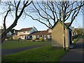
Housing and bus shelter, South Brent
On the left is modern housing arranged at right angles to Sanderspool Cross, at the far left. Confusingly, Sanderspool Cross is also the name of the roundabout (see Image) further up the B3372, which is on the extreme right.
On the right, a significant bus stop - it's the London Inn, timed calling point for the X80 and X38 services from Plymouth to Exeter and Torquay respectively. Except that it's about 100 metres up the hill from the London Inn, which is in a different square (see Image, which shows it). For a somewhat superior bus shelter nearby, see Image However, I was grateful for this one, as my bus was almost half an hour late.
Image: © Derek Harper
Taken: 22 Apr 2009
0.09 miles
5
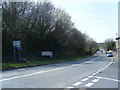
Exeter Road, South Brent
Looking from the bus stop opposite the recently closed London Inn.
Image: © Adrian Platt
Taken: 18 Dec 2010
0.10 miles
6
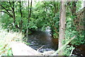
The River Avon
As it flows through South Brent,close to Brent Mill Bridge.
Image: © jeff collins
Taken: 1 Aug 2009
0.11 miles
7
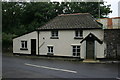
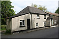
Toll House, Brent Mill
This modest cottage was once a toll house, and stands next to the bridge over the River Avon just off the old A38. Originally this was where the pre 1820 road from Wrangaton and Plymouth came into the village, and it marks the western end of the Ashburton and Totnes Turnpike Trust's responsibilities, the eastern end being in Chudleigh some 20 miles to the east.
Image: © Adrian Platt
Taken: 11 Aug 2008
0.12 miles
8
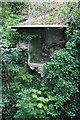
Privy at Brent Mill Toll House
In the yard of the Toll House at Brent Mill Image, right next to the bridge Image is the remains of a privy that has partly collapsed into the river that it originally used to discharge into. The river is eroding the bank below the privy, which obviously is no longer used!
Image: © Adrian Platt
Taken: 11 Aug 2008
0.12 miles
9
Old Toll House by Brent Mill, South Brent
Toll House in the parish of South Brent (South Hams District), Old Toll House, Brent Mill, TQ10.
(For a photo of the derelict tollhouse privy see https://www.flickr.com/photos/tollhouses/2514000478 )
Devon & Dartmoor HER.
HER Number: MDV13155 https://www.heritagegateway.org.uk/Gateway/Results_Single.aspx?uid=MDV13155&resourceID=104
Surveyed
Milestone Society National ID: DV.SBR
Image: © Alan Rosevear
Taken: 22 May 2008
0.12 miles
10
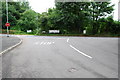
Road junction
This shot shows the minor road that passes over Brent Mill Bridge, to its junction with the B3372 (Exeter road),which runs through South Brent.
Image: © jeff collins
Taken: 1 Aug 2009
0.13 miles