IMAGES TAKEN NEAR TO
Avonwick, SOUTH BRENT, TQ10 9HA
Introduction
This page details the photographs taken nearby to TQ10 9HA by members of the Geograph project.
The Geograph project started in 2005 with the aim of publishing, organising and preserving representative images for every square kilometre of Great Britain, Ireland and the Isle of Man.

There are currently over 7.5m images from over14,400 individuals and you can help contribute to the project by visiting https://www.geograph.org.uk
Image Map
Images are licensed for reuse under creativecommons.org/licenses/by-sa/2.0
Notes
- Clicking on the map will re-center to the selected point.
- The higher the marker number, the further away the image location is from the centre of the postcode.
Image Listing (10 Images Found)
Images are licensed for reuse under creativecommons.org/licenses/by-sa/2.0
Image
Details
Distance
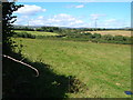
1
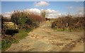
Track near Cutwellcoombe
Leaving the ridge lane from Sign of the Owl Cross to Avonwick at a bend.
Image: © Derek Harper
Taken: 18 Feb 2013
0.12 miles
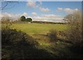
2
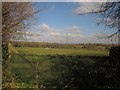
Fields near Cannamore
From the ridge lane between Sign of the Owl Cross and Avonwick.
Image: © Derek Harper
Taken: 18 Feb 2013
0.14 miles
3
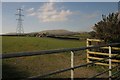
Field and pylon near Cutwellcoombe
From the same junction as Image], looking to the left. I think those are stacks of timber. In the distance is Ugborough Beacon.
Image: © Derek Harper
Taken: 18 Feb 2013
0.19 miles
4
Field, Cannamore
The field is crossed by Ugborough Footpath 4.
Image: © Derek Harper
Taken: 18 Feb 2013
0.22 miles
5
Cannamore from Ugborough Footpath 4
The farm is to the left of the conifers. In the background, southern Dartmoor.
Image: © Derek Harper
Taken: 29 Aug 2006
0.24 miles
6
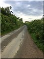
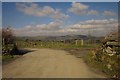
Narrow lane
Heading towards Avonwick, from Sign of the Owl Cross.
Image: © jeff collins
Taken: 14 Jul 2020
0.24 miles
7
End of footpath near Cutwellwalls
Ugborough Footpath 5 crosses a stile (missing from the DCC interactive map) and passes through a gate (secured by gravity, leaning as it is) to reach the ridge lane from Sign of the Owl Cross to Avonwick.
Image: © Derek Harper
Taken: 18 Feb 2013
0.24 miles
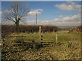
8
Head of valley, Cutwellwalls
From Ugborough Footpath 5, looking across the field above the one shown in Image], with bushes and rough ground is the boggy area in the foreground. Up on the left is Cutwellwalls Farm, on the ridge lane from Sign of the Owl Cross to Avonwick.
Image: © Derek Harper
Taken: 18 Feb 2013
0.24 miles
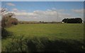
9
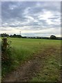
Farmland
In the distance a building belonging to Cannamore Farm can be seen.
Image: © jeff collins
Taken: 14 Jul 2020
0.24 miles
10
Track to Cutwellcoombe
On the left is the waymark denoting the start of Ugborough Footpath 28, which runs parallel to the track down to the farm. In the distance is South Brent, below the edge of the moor and Brent Hill. This is from the junction seen in Image
Image: © Derek Harper
Taken: 18 Feb 2013
0.25 miles