
IMAGES TAKEN NEAR TO
SOUTH BRENT, TQ10 9FA
Introduction
This page details the photographs taken nearby to TQ10 9FA by members of the Geograph project.
The Geograph project started in 2005 with the aim of publishing, organising and preserving representative images for every square kilometre of Great Britain, Ireland and the Isle of Man.

There are currently over 7.5m images from over14,400 individuals and you can help contribute to the project by visiting https://www.geograph.org.uk
Image Map
Images are licensed for reuse under creativecommons.org/licenses/by-sa/2.0
Notes
- Clicking on the map will re-center to the selected point.
- The higher the marker number, the further away the image location is from the centre of the postcode.
Image Listing (35 Images Found)
Images are licensed for reuse under creativecommons.org/licenses/by-sa/2.0
Image
Details
Distance
1
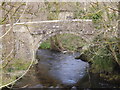
Old bridge, South Brent
Photographed from a grander and more modern stone built bridge with a balustraded parapet. This area is 'Brent Mills' but I was in a rush and saw no definite former water mills.
Image: © Chris Allen
Taken: 1 Apr 2015
0.04 miles
2
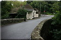
Bridge and Toll House at Brent Mill
The old bridge over the River Avon at Brent Mill, on a typical damp summer Devon day, showing the Toll house Image and the "old" A38 in the background. The privy Image is in the shadow on the left of the bridge.
Update - the bridge is grade II listed and may date back to the C17th and C18th, see http://www.britishlistedbuildings.co.uk/en-99356.
Image: © Adrian Platt
Taken: 11 Aug 2008
0.04 miles
3
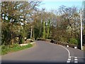
Brent Mill Bridge
A view of the bridge over the Avon shown in Image "C17 or C18 pack-horse bridge widened on north side circa C18 ... widening is probably C18 and the bridge may be C17." http://www.imagesofengland.org.uk/Details/Default.aspx?id=99356&mode=adv
Image: © Derek Harper
Taken: 22 Apr 2009
0.04 miles
4
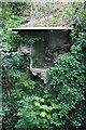
Privy at Brent Mill Toll House
In the yard of the Toll House at Brent Mill Image, right next to the bridge Image is the remains of a privy that has partly collapsed into the river that it originally used to discharge into. The river is eroding the bank below the privy, which obviously is no longer used!
Image: © Adrian Platt
Taken: 11 Aug 2008
0.05 miles
5
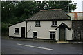
Toll House, Brent Mill
This modest cottage was once a toll house, and stands next to the bridge over the River Avon just off the old A38. Originally this was where the pre 1820 road from Wrangaton and Plymouth came into the village, and it marks the western end of the Ashburton and Totnes Turnpike Trust's responsibilities, the eastern end being in Chudleigh some 20 miles to the east.
Image: © Adrian Platt
Taken: 11 Aug 2008
0.05 miles
6
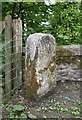
Old Milestone by Brentmill Bridge, South Brent
Carved stone post by the B3372 (was A38), in parish of South Brent (South Hams District), East end of Brentmill Bridge, just off B3372, near old toll house, on muddy verge by small gate, on South side of road. Ashburton tombstone, erected by the Ashburton (Ashburton & Totnes Consolidated) turnpike trust in the 19th century.
Inscription reads:-
BRENT
FROM
ASH
BURTON
VIII
M(ILES)
Devon & Dartmoor HER.
HER Number: MDV3131 https://www.heritagegateway.org.uk/Gateway/Results_Single.aspx?uid=MDV3131&resourceID=104
Milestone Society National ID: DV_PLEX16
Image: © Alan Rosevear
Taken: 22 May 2008
0.05 miles
7
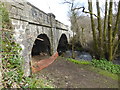
Bridge at South Brent
Photographed from an abutment is this stone bridge that used to carry the old A38 before it was replaced with a dual carriageway. This was as far as I got down the steeply embanked abutment before returning to the solidity of the carriageway.
Image: © Chris Allen
Taken: 1 Apr 2015
0.05 miles
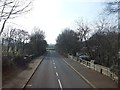
9
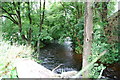
The River Avon
As it flows through South Brent,close to Brent Mill Bridge.
Image: © jeff collins
Taken: 1 Aug 2009
0.06 miles
10
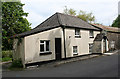
Old Toll House by Brent Mill, South Brent
Toll House in the parish of South Brent (South Hams District), Old Toll House, Brent Mill, TQ10.
(For a photo of the derelict tollhouse privy see https://www.flickr.com/photos/tollhouses/2514000478 )
Devon & Dartmoor HER.
HER Number: MDV13155 https://www.heritagegateway.org.uk/Gateway/Results_Single.aspx?uid=MDV13155&resourceID=104
Surveyed
Milestone Society National ID: DV.SBR
Image: © Alan Rosevear
Taken: 22 May 2008
0.06 miles