IMAGES TAKEN NEAR TO
Aish, SOUTH BRENT, TQ10 9EQ
Introduction
This page details the photographs taken nearby to TQ10 9EQ by members of the Geograph project.
The Geograph project started in 2005 with the aim of publishing, organising and preserving representative images for every square kilometre of Great Britain, Ireland and the Isle of Man.

There are currently over 7.5m images from over14,400 individuals and you can help contribute to the project by visiting https://www.geograph.org.uk
Image Map
Images are licensed for reuse under creativecommons.org/licenses/by-sa/2.0
Notes
- Clicking on the map will re-center to the selected point.
- The higher the marker number, the further away the image location is from the centre of the postcode.
Image Listing (81 Images Found)
Images are licensed for reuse under creativecommons.org/licenses/by-sa/2.0
Image
Details
Distance
1
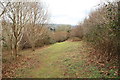
Footpath through Penstave Copse
The footpath to Lydia Bridge running through a Woodland Trust area.
Image: © Guy Wareham
Taken: 12 Apr 2013
0.07 miles
2
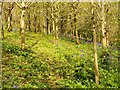
Penstave Copse
New planting by the Woodland Trust in an upper field near the lane, and with bluebells thriving - also lesser celandines and dog's mercury.
See the management plan at http://www.woodlandtrust.org.uk/woodfile/650/management-plan.pdf?cb=adbb52cbbc894ba69571c2d16769287c .
Image: © Derek Harper
Taken: 4 May 2014
0.08 miles
3
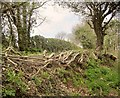
Laid hedge by Penstave Copse
Alongside the lane from Aish to Binnamore, and with a notice asking that new shoots be not cut.
Image: © Derek Harper
Taken: 4 May 2014
0.09 miles
4
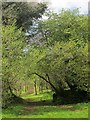
Path, Penstave Copse
Leaving the glade shown in Image] and heading towards the top of the wood.
The Management Plan for Penstave Copse is at http://www.woodlandtrust.org.uk/woodfile/650/management-plan.pdf?cb=adbb52cbbc894ba69571c2d16769287c .
Image: © Derek Harper
Taken: 4 May 2014
0.10 miles
5
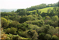
Across the Avon valley
From a little further southeast along South Brent bridleway 13 than Image
Image: © Derek Harper
Taken: 16 Sep 2020
0.10 miles
6
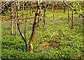
Penstave Copse
A glimmer of sunshine, so here's a view past bluebells down to the path shown in Image] from a path that crosses it and reaches the lane to Aish further east than the right of way.
The Management Plan for Penstave Copse is at http://www.woodlandtrust.org.uk/woodfile/650/management-plan.pdf?cb=adbb52cbbc894ba69571c2d16769287c .
Image: © Derek Harper
Taken: 4 May 2014
0.10 miles
7
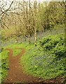
Penstave Copse
This must be South Brent Footpath 7, dropping through the Woodland Trust property amid bluebells.
The Management Plan for Penstave Copse is at http://www.woodlandtrust.org.uk/woodfile/650/management-plan.pdf?cb=adbb52cbbc894ba69571c2d16769287c .
Image: © Derek Harper
Taken: 4 May 2014
0.10 miles
8
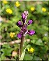
Orchid, Penstave Copse
An early purple orchid (Orchis mascula) amid lesser celandines at the top of the wood.
Image: © Derek Harper
Taken: 4 May 2014
0.10 miles
9
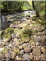
River Avon, Penstave Copse
Looking downstream from the same spot as Image
Image: © Derek Harper
Taken: 4 May 2014
0.11 miles
10
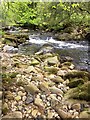
River Avon, Penstave Copse
Looking upstream over rocks; Image looks downstream from the same spot.
Image: © Derek Harper
Taken: 4 May 2014
0.11 miles