IMAGES TAKEN NEAR TO
SOUTH BRENT, TQ10 9EP
Introduction
This page details the photographs taken nearby to TQ10 9EP by members of the Geograph project.
The Geograph project started in 2005 with the aim of publishing, organising and preserving representative images for every square kilometre of Great Britain, Ireland and the Isle of Man.

There are currently over 7.5m images from over14,400 individuals and you can help contribute to the project by visiting https://www.geograph.org.uk
Image Map
Images are licensed for reuse under creativecommons.org/licenses/by-sa/2.0
Notes
- Clicking on the map will re-center to the selected point.
- The higher the marker number, the further away the image location is from the centre of the postcode.
Image Listing (17 Images Found)
Images are licensed for reuse under creativecommons.org/licenses/by-sa/2.0
Image
Details
Distance
1

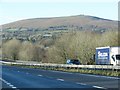
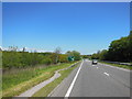
A38 eastbound south west of South Brent
There are advance warning signs for the exit slip road for South Brent. The sign warning of a slippery road appears temporary but has been there for many months
Image: © David Smith
Taken: 16 Apr 2015
0.05 miles
4
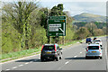
Devon Expressway approaching Woodpecker Interchange
Image: © David Dixon
Taken: 15 Apr 2022
0.13 miles
5
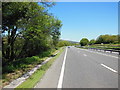
Ugborough : Devon Expressway A38
Looking along the A38.
Image: © Lewis Clarke
Taken: 3 Dec 2019
0.13 miles
6
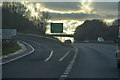
The A38 eastbound near the South Brent turn off
Image: © Ian S
Taken: 26 May 2013
0.14 miles
7
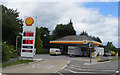
Service station
On an unmarked road near the A38 at Zeaston.
Image: © Robert Ashby
Taken: 7 Aug 2015
0.19 miles
10
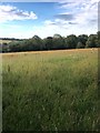
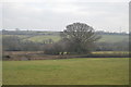
Grassland
Probably waiting to be harvested.
Image: © jeff collins
Taken: 4 Aug 2020
0.23 miles