IMAGES TAKEN NEAR TO
Courtenay Park, SOUTH BRENT, TQ10 9BT
Introduction
This page details the photographs taken nearby to Courtenay Park, TQ10 9BT by members of the Geograph project.
The Geograph project started in 2005 with the aim of publishing, organising and preserving representative images for every square kilometre of Great Britain, Ireland and the Isle of Man.

There are currently over 7.5m images from over14,400 individuals and you can help contribute to the project by visiting https://www.geograph.org.uk
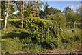
Image Map
Images are licensed for reuse under creativecommons.org/licenses/by-sa/2.0
Notes
- Clicking on the map will re-center to the selected point.
- The higher the marker number, the further away the image location is from the centre of the postcode.
Image Listing (81 Images Found)
Images are licensed for reuse under creativecommons.org/licenses/by-sa/2.0
Image
Details
Distance
2
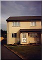
Houses at the end of Heather Park, South Brent
These houses were built on land formerly occupied by the South Brent to Kingsbridge branch line. The whole road is in the same style as this end and middle terrace house.
Image: © Ruth Sharville
Taken: Unknown
0.07 miles
3
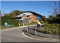
South Brent Primary School
A new school building seen across Totnes Road. A metre or two to the left of the camera is the crossing point of four hectads.
Image: © Derek Harper
Taken: 17 Oct 2010
0.07 miles
6
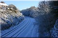
Railway cutting, South Brent
This is the South Devon Railway mainline designed by I K Brunel. This cutting is immediately east of the former station yard. The vehicle tracks in the snow on the right of the railway lines follow the course of the Kingsbridge branchline which ran round to the right in a cutting now hidden by the trees. ironically the branchline opened after the mainline had been converted from Mr Brunel's Broad Gauge and closed when the mainline still operated. The tracks are used by Network Rail for access to the railway lines, they use the former signal box, Image occasionally as a mess-room and store when working in the area.
Image: © Adrian Platt
Taken: 18 Dec 2010
0.08 miles
8
Totnes Road
The entrance to the new primary school is on the right.
Image: © Ruth Sharville
Taken: 12 Apr 2009
0.09 miles
9

Junction of Pool Park and Shipley Close
Image: © Ruth Sharville
Taken: 29 Dec 2015
0.09 miles
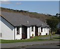
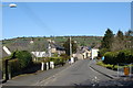
10
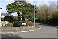
Junction of Chapelfields and Totnes Road
Chapelfields leads to Courtenay Park and Ashwood.
Image: © Ruth Sharville
Taken: 14 Mar 2009
0.09 miles