IMAGES TAKEN NEAR TO
Station Road, SOUTH BRENT, TQ10 9BB
Introduction
This page details the photographs taken nearby to Station Road, TQ10 9BB by members of the Geograph project.
The Geograph project started in 2005 with the aim of publishing, organising and preserving representative images for every square kilometre of Great Britain, Ireland and the Isle of Man.

There are currently over 7.5m images from over14,400 individuals and you can help contribute to the project by visiting https://www.geograph.org.uk
Image Map
Images are licensed for reuse under creativecommons.org/licenses/by-sa/2.0
Notes
- Clicking on the map will re-center to the selected point.
- The higher the marker number, the further away the image location is from the centre of the postcode.
Image Listing (155 Images Found)
Images are licensed for reuse under creativecommons.org/licenses/by-sa/2.0
Image
Details
Distance
1
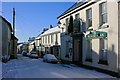
A quiet Saturday morning in South Brent
The snowfall reduced traffic to a trickle, it was wonderful until it became slushy and dirty with salt.
This is Station Road, looking towards the Anchor with its jetty over the pavement. The Royal Oak is one of 2 pubs still functioning in the village, the Anchor being a closed one now used as a newsagents and shop.
Image: © Adrian Platt
Taken: 18 Dec 2010
0.03 miles
2
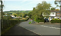
Station Approach, South Brent
The main railway line is on the left over the wall, but no station is there now. On the right is Brookwood Close.
Image: © Derek Harper
Taken: 16 Sep 2020
0.04 miles
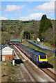
3
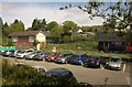
Former station at South Brent
A multiple unit heads for Ivybridge and Plymouth as it passes the old signal box. In front is the town car park. In the background is housing on Brookswood Close.
Image: © Derek Harper
Taken: 4 May 2014
0.04 miles
4
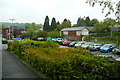
South Brent station
The station yard is now a car park. On the far side of the railway line the former signal box is boarded up.
Image: © Graham Horn
Taken: 14 May 2012
0.05 miles
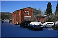
6
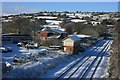
A snowy station yard, South Brent
South Brent was once a busy junction station on the South Devon Railway mainline to Plymouth. It was closed in 1963 but Image provides a snapshot of it in 1958.
Some of the infrastructure remains, the signal box is on what remains of the island platform, and the goods shed is now a busy dental surgery, see Image The rest of the yard is used for parking and has a small factory in one part.
Snow is not new here; in March 1891 a drama occurred when the GWR's premier daily express from Paddington to Plymouth, nicknamed "The Zulu", was stranded here for 4 days in what was called The Great Blizzard. Greg Wall's Book of South Brent published by Halsgrove in 2005, has an interesting account from newspaper reports of the time.
See Image for the same scene.
Image: © Adrian Platt
Taken: 18 Dec 2010
0.05 miles
7
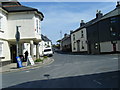
South Brent Post Office and Station Road
Image: © Colin Pyle
Taken: 10 Apr 2010
0.06 miles
8
Train at South Brent
High Speed train passing the disused signalbox at South Brent.
Image: © Wayland Smith
Taken: 12 Apr 2009
0.06 miles
9

Cottages in Totnes Road, South Brent
These brightly painted cottages are opposite the old militia barracks site in Totnes Road Image
Image: © Adrian Platt
Taken: 12 Oct 2008
0.06 miles
10
Primrose Junction Dental Surgery, South Brent
The village is lucky to have a dental surgery, and for this building to have been saved and converted into it. Originally this area was the railway station yard, and this building was the Goods Shed built by the GWR. The conversion was excellent, with a mezzanine floor added that fits in with the original internal structural ironwork. See Image for a different view.
Image: © Adrian Platt
Taken: 18 Dec 2010
0.07 miles