IMAGES TAKEN NEAR TO
Pembury Road, TONBRIDGE, TN9 2JF
Introduction
This page details the photographs taken nearby to Pembury Road, TN9 2JF by members of the Geograph project.
The Geograph project started in 2005 with the aim of publishing, organising and preserving representative images for every square kilometre of Great Britain, Ireland and the Isle of Man.

There are currently over 7.5m images from over14,400 individuals and you can help contribute to the project by visiting https://www.geograph.org.uk
Image Map
Images are licensed for reuse under creativecommons.org/licenses/by-sa/2.0
Notes
- Clicking on the map will re-center to the selected point.
- The higher the marker number, the further away the image location is from the centre of the postcode.
Image Listing (692 Images Found)
Images are licensed for reuse under creativecommons.org/licenses/by-sa/2.0
Image
Details
Distance
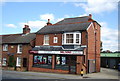
1
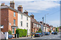
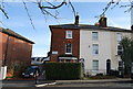
45 - 53 Pembury Road
Victorian houses on Pembury Road, with the first terrace, nos 65 - 69 with a name plaque Ventnor Place, marked on the 1867 1:500 plan, as is the third terrace, nos 77 - 87 (see Image for closer view). The second terrace is first shown on the 1896 25 inch map.
Image: © Ian Capper
Taken: 20 Apr 2023
0.00 miles
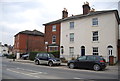
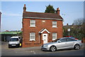
10
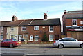
Milnemont Cottage, Pembury Rd
Victorian brick cottage.
Image: © N Chadwick
Taken: 11 Mar 2009
0.02 miles