IMAGES TAKEN NEAR TO
Fosse Road, TONBRIDGE, TN9 1HX
Introduction
This page details the photographs taken nearby to Fosse Road, TN9 1HX by members of the Geograph project.
The Geograph project started in 2005 with the aim of publishing, organising and preserving representative images for every square kilometre of Great Britain, Ireland and the Isle of Man.

There are currently over 7.5m images from over14,400 individuals and you can help contribute to the project by visiting https://www.geograph.org.uk
Image Map
Images are licensed for reuse under creativecommons.org/licenses/by-sa/2.0
Notes
- Clicking on the map will re-center to the selected point.
- The higher the marker number, the further away the image location is from the centre of the postcode.
Image Listing (1462 Images Found)
Images are licensed for reuse under creativecommons.org/licenses/by-sa/2.0
Image
Details
Distance
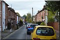
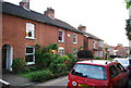
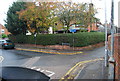
1
Fosse Road
Cul-de-sac of late 19th Century terraced housing, first marked on the 1896 25 inch map. The trees in the background mark the line of the ditch and bank town walls, known as The Fosse, hence this road's name.
Image: © Ian Capper
Taken: 20 Apr 2023
0.01 miles
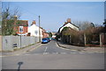
2
Estate Department Offices, Tonbridge School
Image: © N Chadwick
Taken: 20 May 2009
0.02 miles
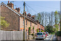
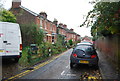
5
Fosse Rd
A street of Victorian terraced houses built bin the 1870s.
Image: © N Chadwick
Taken: 20 May 2009
0.02 miles
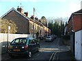
6
Lodge Rd
A street of Victorian terraced houses built bin the 1870s.
Image: © N Chadwick
Taken: 20 May 2009
0.03 miles
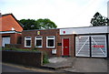
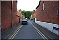
7
House at the junction of Lodge Rd & Lansdowne Rd, Tonbridge.
Image: © N Chadwick
Taken: 3 Nov 2008
0.03 miles
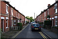
8
Lansdowne Rd, Tonbridge.
Terraced housing, in north Tonbridge.
Image: © N Chadwick
Taken: 3 Nov 2008
0.03 miles