IMAGES TAKEN NEAR TO
TN8 6ZR
Introduction
This page details the photographs taken nearby to TN8 6ZR by members of the Geograph project.
The Geograph project started in 2005 with the aim of publishing, organising and preserving representative images for every square kilometre of Great Britain, Ireland and the Isle of Man.

There are currently over 7.5m images from over14,400 individuals and you can help contribute to the project by visiting https://www.geograph.org.uk
Image Map
Images are licensed for reuse under creativecommons.org/licenses/by-sa/2.0
Notes
- Clicking on the map will re-center to the selected point.
- The higher the marker number, the further away the image location is from the centre of the postcode.
Image Listing (210 Images Found)
Images are licensed for reuse under creativecommons.org/licenses/by-sa/2.0
Image
Details
Distance
1
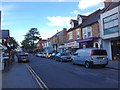
Edenbridge
The High Street closed for a Christmas Fayre.
Image: © Peter Trimming
Taken: 26 Nov 2022
0.01 miles
3
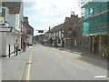
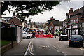
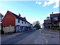
Edenbridge
The main high street through Edenbridge used to be always busy with cars and lorries until the new by-pass was opened recently.
Image: © Nigel Freeman
Taken: 23 Aug 2005
0.02 miles
4
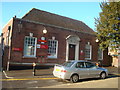
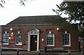
Royal Mail Delivery Office, Edenbridge
Image: © Stacey Harris
Taken: 18 Jan 2009
0.02 miles
8
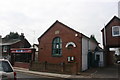
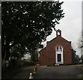
Bridges, High St, Edenbridge
A christian centre using the old Ebeneezer Chapel.
Image: © N Chadwick
Taken: 15 Feb 2010
0.04 miles
9
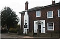
Edenbridge Police Station
Just off Edenbridge High Street.
Image: © David Anstiss
Taken: 10 Jul 2011
0.04 miles