IMAGES TAKEN NEAR TO
Sandy Lane, HARTFIELD, TN7 4ER
Introduction
This page details the photographs taken nearby to Sandy Lane, TN7 4ER by members of the Geograph project.
The Geograph project started in 2005 with the aim of publishing, organising and preserving representative images for every square kilometre of Great Britain, Ireland and the Isle of Man.

There are currently over 7.5m images from over14,400 individuals and you can help contribute to the project by visiting https://www.geograph.org.uk
Image Map
Images are licensed for reuse under creativecommons.org/licenses/by-sa/2.0
Notes
- Clicking on the map will re-center to the selected point.
- The higher the marker number, the further away the image location is from the centre of the postcode.
Image Listing (39 Images Found)
Images are licensed for reuse under creativecommons.org/licenses/by-sa/2.0
Image
Details
Distance
1
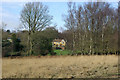
White Platt
One of a few houses in the Hillside Farm inclosure on Ashdown Forest.
Image: © Robin Webster
Taken: 19 Jan 2007
0.07 miles
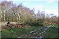
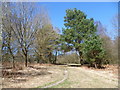
2

Path uphill from Tabell Ghyll
Ashdown Forest is a former medieval hunting forest, and is the highest ridge of the High Weald. At ten square miles it is the largest open access area in the South East. Ashdown Forest was purchased by East Sussex County Council from the De La Warr family in 1988. It is now managed by a Board of Conservators. Although it was the second half of April, an exceptionally cold March meant that trees were showing little sign of bursting into leaf.
This path leads uphill from Tabell Ghyll to reach the ground of Colemans Hatch Cricket Club beyond the top of the hill.
Image: © Marathon
Taken: 20 Apr 2013
0.10 miles
3

Path alongside Colemans Hatch Cricket Club
Ashdown Forest is a former medieval hunting forest, and is the highest ridge of the High Weald. At ten square miles it is the largest open access area in the South East. Ashdown Forest was purchased by East Sussex County Council from the De La Warr family in 1988. It is now managed by a Board of Conservators. Although it was the second half of April, an exceptionally cold March meant that trees were showing little sign of bursting into leaf.
This is the ground of Colemans Hatch Cricket Club. The path leads down to Tabell Ghyll.
Image: © Marathon
Taken: 20 Apr 2013
0.12 miles
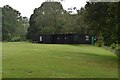
4
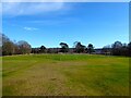
Colemans Hatch Cricket Ground
Located on Sandy Lane within Ashdown Forest.
Image: © Simon Carey
Taken: 26 Feb 2022
0.13 miles
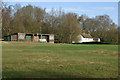
5

Colemans Hatch Cricket Club
Ashdown Forest is a former medieval hunting forest, and is the highest ridge of the High Weald. At ten square miles it is the largest open access area in the South East. Ashdown Forest was purchased by East Sussex County Council from the De La Warr family in 1988. It is now managed by a Board of Conservators. Although it was the second half of April, an exceptionally cold March meant that trees were showing little sign of bursting into leaf.
This is the ground of Colemans Hatch Cricket Club. Notice the fire beater in the foreground.
Image: © Marathon
Taken: 20 Apr 2013
0.15 miles
6
Felled Pine
Blown down by the winds of 18 January 2007.
Image: © Robin Webster
Taken: 19 Jan 2007
0.15 miles
7
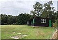
Cricket Pavilion
The cricket field just off Sandy Lane at Coleman’s Hatch. On the Vanguard Way which passes behind the pavilion.
Image: © Chris Thomas-Atkin
Taken: 4 Aug 2019
0.15 miles
8
Path in Ashdown Forest
Ashdown Forest is a former medieval hunting forest, and is the highest ridge of the High Weald. At ten square miles it is the largest open access area in the South East. Ashdown Forest was purchased by East Sussex County Council from the De La Warr family in 1988. It is now managed by a Board of Conservators. Although it was the second half of April, an exceptionally cold March meant that trees were showing little sign of bursting into leaf.
This path lies between Tabell Ghyll and the ground of Colemans Hatch Cricket Club.
Image: © Marathon
Taken: 20 Apr 2013
0.15 miles
10
Cricket Pavilion, Colemans Hatch
The cricket ground is a small inclosure on Ashdown Forest. The house on the right is Spinningdale.
Image: © Robin Webster
Taken: 19 Jan 2007
0.16 miles