IMAGES TAKEN NEAR TO
HARTFIELD, TN7 4DQ
Introduction
This page details the photographs taken nearby to TN7 4DQ by members of the Geograph project.
The Geograph project started in 2005 with the aim of publishing, organising and preserving representative images for every square kilometre of Great Britain, Ireland and the Isle of Man.

There are currently over 7.5m images from over14,400 individuals and you can help contribute to the project by visiting https://www.geograph.org.uk
Image Map (Loading...)


Getting Data...Please wait
Leaflet Map data © OpenStreetMap
Images are licensed for reuse under creativecommons.org/licenses/by-sa/2.0
Notes
- Clicking on the map will re-center to the selected point.
- The higher the marker number, the further away the image location is from the centre of the postcode.
Image Listing (47 Images Found)
Images are licensed for reuse under creativecommons.org/licenses/by-sa/2.0
Image
Details
Distance
1
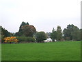
Gutter Field/Hop Garden Field
The name of the fields according to Hartfield's 1842 tithe map that have been merged to form a larger unit. Gutter Field was in the foreground whilst Hop Garden Field was further up the slope. Both are bonded to the west by Jib Jacks Hill, the B2026.
Image: © Simon Carey
Taken: 10 Aug 2021
0.08 miles
2
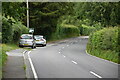
Jib Jacks Hill
The B2026 heading south to the Ashdown Forest and eventually Maresfield.
Image: © Simon Carey
Taken: 10 Aug 2021
0.08 miles
3
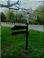
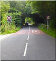
Fingerpost Signs by Jibjacks Hill
As well as the established fingerpost signs pointing the way to the destinations, a newer set of blank fingerpost signs has appeared nearby.
Image: © Ed of the South
Taken: 14 Apr 2014
0.11 miles
4
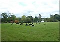
Black sheep in a field
This was a whole field of black sheep near Newton's Hill, seen from a footpath.
Image: © Marathon
Taken: 3 Oct 2020
0.12 miles
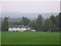
5

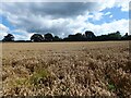
Hook Field
The name of the field according to Hartfield's 1842 tithe map with Hook Farm House visible at the northern end.
Image: © Simon Carey
Taken: 10 Aug 2021
0.13 miles
7
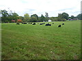
A field of black sheep
This was a whole field of black sheep near Newton's Hill, seen from a footpath.
Image: © Marathon
Taken: 3 Oct 2020
0.13 miles
8

Further Field
The name of the field according to Hartfield's 1842 tithe map bounded to the east by Cotchford Hill, the B2026.
Image: © Simon Carey
Taken: 10 Aug 2021
0.13 miles