IMAGES TAKEN NEAR TO
Withyham, HARTFIELD, TN7 4BA
Introduction
This page details the photographs taken nearby to TN7 4BA by members of the Geograph project.
The Geograph project started in 2005 with the aim of publishing, organising and preserving representative images for every square kilometre of Great Britain, Ireland and the Isle of Man.

There are currently over 7.5m images from over14,400 individuals and you can help contribute to the project by visiting https://www.geograph.org.uk
Image Map
Images are licensed for reuse under creativecommons.org/licenses/by-sa/2.0
Notes
- Clicking on the map will re-center to the selected point.
- The higher the marker number, the further away the image location is from the centre of the postcode.
Image Listing (51 Images Found)
Images are licensed for reuse under creativecommons.org/licenses/by-sa/2.0
Image
Details
Distance
1
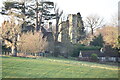
Gatehouse, Old Buckhurst
Grade II listed https://historicengland.org.uk/listing/the-list/list-entry/1028066 tower
Image: © Oast House Archive
Taken: 22 Jul 2011
0.02 miles
2
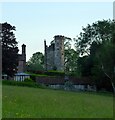
Tower, Old Buckhurst
The original manor house stood to the west of the tower and was first mentioned in 1274. By the 16th century it had been rebuilt by the Sackville family who would later become the Earls of De La Warr and still reside in the newer Buckhurst Park to the east. As the family got richer and advanced through Elizabethan society it abandoned the house and moved to Knole Park in Kent. The building was largely demolished just after 1600 with the bricks reused to build Sackville College in East Grinstead. The tower, originally a gatehouse, and part of the southern wing are all that remains.
Image: © Simon Carey
Taken: 5 Jun 2021
0.03 miles
3
Gatehouse, Old Buckhurst
Grade II listed.
Image: © N Chadwick
Taken: 9 Jan 2022
0.03 miles
4
Gatehouse, Old Buckhurst
Grade II listed.
Image: © N Chadwick
Taken: 9 Jan 2022
0.03 miles
5
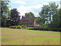
Old Buckhurst, Withyham, Hartfield
Image: © Oast House Archive
Taken: 22 Jul 2011
0.03 miles
6
Old Buckhurst
A very old house, home of the Sackvilles for over 600 years
http://theweald.org/P2.asp?PId=Wi.Buckhu
Image: © N Chadwick
Taken: 6 Nov 2009
0.03 miles
7
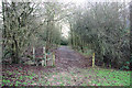
Bog Shaw
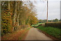
The footpath leaves a wet and muddy field and enters a wet and muddy wood, appropriately named Bog Shaw.
Image: © Robin Webster
Taken: 20 Jan 2007
0.06 miles
8
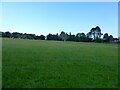
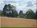
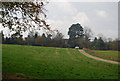
The Meadow
The name of the field according to Withyham's 1842 tithe map with Old Buckhurst visible on the right.
Image: © Simon Carey
Taken: 5 Jun 2021
0.06 miles
9
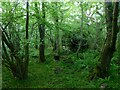
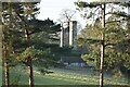
Bog Shaw
With the remains of an old hut just visible through the undergrowth.
Image: © Simon Carey
Taken: 5 Jun 2021
0.10 miles